
It was going to be an El Niño to end all El Niños. The warmest ocean temperature anomalies on record blossomed in its core, the largest area of exceptionally warm water ever seen in the tropical Pacific. The California drought was death watch — it would bring “one storm after another like a conveyor belt.” It was named Godzilla.
And now it’s dead.
RIP, Godzilla El Niño.
Over the past few weeks, the equatorial Pacific has been cooling. The extreme tropical temperatures that broke records earlier this winter have waned, and El Niño, though still present, is a shadow of its former Godzilla self. It signals a possible shift to the Pacific’s other phase, La Niña.
The strength of El Niño is measured by how abnormally warm the ocean water is in the equatorial Pacific. El Niño can be classified as “very strong” if surface waters are running at least 2 degrees Celsius warmer than average for at least three months in a row. This has only happened three times on record: 1982-1983, 1997-1998 and this winter, 2015-2016.
Not only did this year’s El Niño become one of the top three strongest on record, it also set a new record for peak “instantaneous” strength. There are many zones in the Pacific that are used to quantify the strength of an El Niño, including the often-cited Niño-3.4 zone. Ocean surface temperature is measured and averaged over the entire region in periods of a week, a month and three months. The records in this region are typically broken by fractions of degrees.
However, in mid-November 2015, the Niño-3.4 region set a new record high for weekly temperature — 3 degrees Celsius, or 5.4 degrees Fahrenheit, above average. It was the largest departure ever recorded on the scale of one week in that region.
It is now down to around 1 degree Celsius this week, for the first time since July 2015.
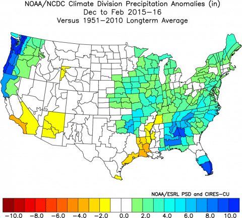
Despite the hype, El Niño didn’t do great things for California like many hoped it would. The other two “very strong” El Niños brought an exceptional amount of rain and snowfall to California, but this year wasn’t anything like that.
Instead of torrential rain in Southern California (and the mudslides that came along with it), the region ended winter with well-below average precipitation. Temperature departures were warm across California and the entire U.S., despite forecasts for cooler than average conditions in the South.
Even worse, California statewide snowpack was just 87 percent of average at its peak. It’s true that this year’s snowfall was a huge improvement over the previous winter, but the amount of water stored in the snow has fallen short of what was hoped for, and even expected, due to a very strong El Niño. Snowfall across the Sierra Mountains is just as important — if not more — for drought conditions as the rain that runs off into reservoirs. The winter snowpack provides around 30 percent of California’s water, frozen on mountain peaks until it melts in the spring.
As El Niño fades, the Pacific is heading into neutral or even La Niña conditions.
Anthony Barnston, chief forecaster at Columbia University’s International Research Institute for Climate and Society, told Climate Central that the tropical Pacific’s cooling means “it’s almost a certainty that [the tropical Pacific Ocean is] going to go back to neutral in about two months.”
IRI forecasts a 50 percent chance of La Niña developing by early fall, and just over a 50 percent chance by next winter. NOAA’s climate forecasting system predicts equatorial sea surface temperatures to plummet in the next few months, reaching neutral conditions by July and La Niña conditions by August.
Those forecasts don’t always pan out; we waited for about a year from early 2014 to early 2015 for El Niño forecasts to finally prove right. But let’s assume we do hit La Niña, since history tells us there’s a decent shot of it after a very strong El Niño. What does that mean for weather?
The honest answer is we don’t know for sure, and you should be skeptical of anyone who does claim to know. We have an idea of how the weather could be affected based on what has happened in the past, but we learned the hard way this year that even super-strong events in the tropical Pacific don’t necessarily have predictable impacts on U.S. weather.
The first and most-often cited impact of La Niña is an increase in hurricane activity in the North Atlantic. Even in neutral conditions, this effect can be seen. The mechanism is pretty straightforward — wind shear, or the change in wind speed with height as you go up in the atmosphere, is detrimental to hurricane development. During La Niña, there tends to be less wind shear over the North Atlantic. During El Niño, there’s more.
But that doesn’t say anything about whether sea surface temperatures will be warm enough to fuel more hurricanes, or whether there will be a huge dome of high pressure over the North Atlantic that could prevent storm development. It only means that in all likelihood, wind shear will be lower on average, which means hurricanes will have one less hurdle to jump.
The jet stream changes during La Niña, too. Instead of El Niño’s strong jet stream that generally bring storms to the southern tier of the U.S., La Niña tends to create a weaker, wavier jet stream that brings more rain and storms to the northern states. This effect is most pronounced in the winter.
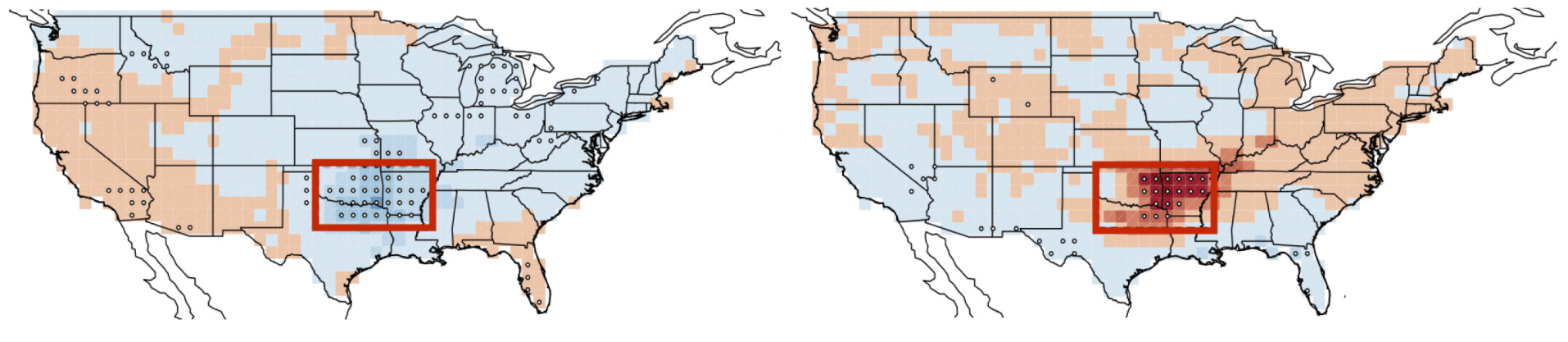
El Nino (left) tends to dampen tornado activity, illustrated in shades of blue, in the boxed region, while La Nina (right), which is shown in red, acts to increase it. (Allen et al., Nature Geoscience, 2015)
It also have an influence on severe weather later this year or next year. A team of scientists led by John Allen at IRI has been looking into how El Niño and La Niña could be contributing to the severity of tornado seasons. On average, they found that El Niños tend to suppress tornado activity in the U.S., while La Niñas tend to increase it.
But remember, these are just average weather patterns over all past La Niñas, and there’s plenty of room for deviation from this script. Southern California can tell you all about that.
