NASA satellites provide invaluable information on climate change that can’t be had from any other source. The Earth Sciences program by NASA gives us a perspective that you can only get from space, as seen in their new Images of Change collection featuring images of different locations on planet earth.
If President Donald Trump plans to cut NASA’s climate science program as he has said he will, calling it “politicized science,” expect a blackout of this series for four, or Lord help us, eight years.
What a loss.
We’ve already gotten a blackout from the Environmental Protection Agency. Our president enacted a media blackout of the EPA January 24, blocking the agency from posting further social media posts.
But some tribes, cities and states have their own climate plans, and they’re not budging. In response to Trump, California Governor Jerry Brown said recently his state would launch their own satellite.
Climate change is the biggest issue mankind will ever have to face. We need more Jerry Browns, and fewer Donald Trumps. And during the Trump era, we’ll need more activists. Let’s get to it.
Below are examples of what NASA is able to provide through its Images of Change program:
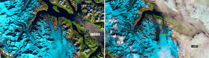
Courtesy U.S. Geological Survey (USGS)
On June 28, 2016, a 4,000-foot-high mountainside in Glacier Bay National Park and Preserve collapsed, dropping rocky debris equivalent to 60 million mid-size SUVs onto nearby Lamplugh Glacier. Seismologists estimated that the material tumbled down the mountain for nearly one minute and then continued to slide along the glacier for another 6 miles. The southeast corner of Alaska, where this event took place, is geologically active and considered a hotspot for such landslides.
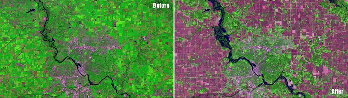
Courtesy U.S. Geological Survey (USGS)
Storms that dropped some 10 inches of rain swelled the Cedar River to 6 feet above its major flood-stage designation at Cedar Rapids, Iowa, on September 27, 2016. Authorities advised some 10,000 residents to evacuate. In these images, the countryside appears green during the growing season (July) and magenta when the crops were ready for harvest (September).
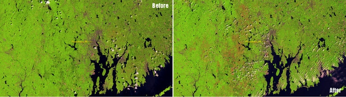
Courtesy U.S. Geological Survey (USGS)
An outbreak of European gypsy moth caterpillars defoliated forests across southern New England and the Mid-Atlantic region of the U.S. during spring and summer, 2016. In the 2015 image of countryside surrounding Providence, Rhode Island, healthy forest appears light green. Damage from the caterpillars appears as a dull peach color in the 2016 image. Two successive dry springs and an accompanying drought, which weakened a ground-dwelling fungus that can kill the caterpillars, are considered responsible for the unusually severe outbreak.
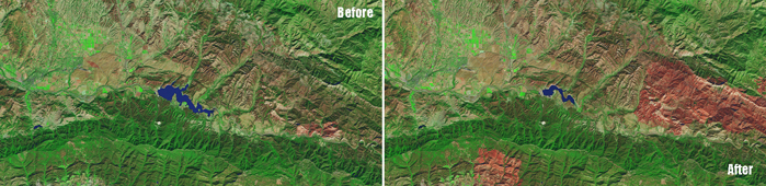
Courtesy U.S. Geological Survey (USGS)
The amount of water in Lake Cachuma has fallen to about 7 percent of capacity, the result of a persistent drought in Southern California. The decline has exposed much of the bottom of the reservoir, which provides drinking water to Santa Barbara. Some 20 percent of the state has suffered exceptional drought, the most extreme drought classification, since early 2014.
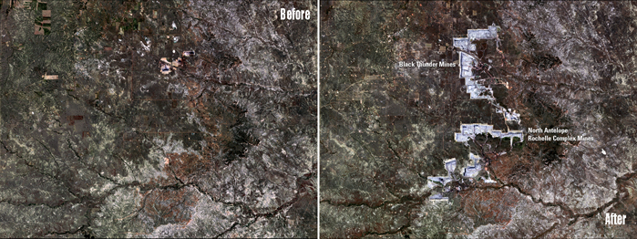
Courtesy U.S. Geological Survey (USGS)
Wyoming’s Powder River Basin hosts the North Antelope Rochelle Complex—largest coal mine in the U.S.—and the Black Thunder Mine. Together, they produced 22 percent of the U.S. coal supply in 2014. These images show the landscape’s change from predominantly agricultural use to open-pit mining. USGS officials estimate that these mines have less than 20 years of economically recoverable coal remaining, after which the companies will be required to reclaim the land.
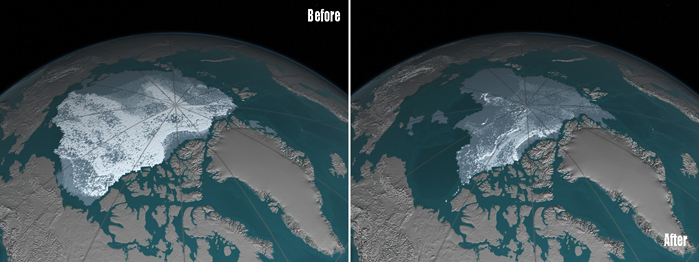
Courtesy U.S. Geological Survey (USGS)
The area covered by Arctic sea ice at least four years old has decreased from 718,000 square miles (1,860,000 square kilometers) in September 1984 to 42,000 square miles (110,000 square kilometers) in September 2016. Ice that has built up over the years tends to be thicker and less vulnerable to melting away than newer ice. In these visualizations of data from buoys, weather stations, satellites and computer models, the age of the ice is indicated by shades ranging from blue-gray for the youngest ice to white for the oldest.