1998 Year of the Ocean
IMPACTS OF GLOBAL CLIMATE CHANGE—
WITH EMPHASIS ON U.S. COASTAL AREAS
Contents
| 1. EXECUTIVE SUMMARY | G-2 |
| 2. INTRODUCTION | G-6 |
| 3. SEASONAL TO INTERANNUAL CLIMATE IMPACTS | G-8 |
| 4. DECADAL TO CENTENIAL CLIMATE IMPACTS | G-17 |
| 5. GLOBAL CLIMATE CHANGE IMPACTS ON U.S. COASTAL AREAS | G-24 |
| 6. REFERENCES | G-43 |
| 7. DOMESTIC LEGAL REGIME | G-47 |
| 8. LIST OF ACRONYMS | G-52 |
This Year of the Ocean document was prepared as a background discussion paper and does not necessarily reflect the policies of the U.S. Government or the U.S. Government agencies that participated in its preparation.
EXECUTIVE SUMMARY
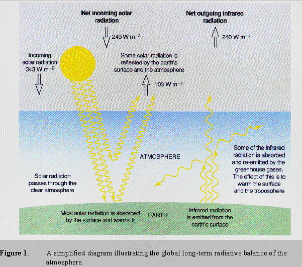
The Earth’s weather and climate are the result of the redistribution of heat. The major source of heat to the surface of the Earth is the sun, principally through incoming visible radiation most of which is absorbed by the Earth’s surface. This radiation is redistributed by the ocean and the atmosphere with the excess radiated back into space as longer wavelength, infrared radiation. Clouds and other gases, primarily water vapor and carbon dioxide, absorb the infrared radiation emitted by the Earth’s surface and remit their own heat at much lower temperatures. This "traps" the Earth’s radiation and makes the Earth much warmer than it would be otherwise.
Most of the incoming solar radiation is received in tropical regions while very little is received in polar regions especially during winter months. Over time, energy absorbed near the equator spreads to the colder regions of the globe, carried by winds in the atmosphere and by currents in the ocean. Compared to the atmosphere, the ocean is much denser and has a much greater ability to store heat. The ocean also moves much more slowly than the atmosphere. Thus, the ocean and the atmosphere interact on different time scales. The ocean moderates seasonal and longer variations by storing and transporting, via ocean currents, large amounts of heat around the globe, eventually resulting in changing weather patterns.
The ocean also plays an important role in climate change. Long-term impacts of climate change in coastal areas, such as sea level rise or storm surges, could result in the increased erosion of shores and associated habitat, increased salinity of estuaries and freshwater aquifers, altered tidal ranges in rivers and bays, changes in sediment and nutrient transport, and increased coastal flooding. Such changes have considerable implications for U.S. coastal areas where the majority of the country's population and significant economic activity is concentrated.
The purpose of this document is to consider how the ocean influences weather and climate and how climatic changes could impact valuable coastal areas. It also addresses the barriers to progress and the opportunities presented by the 1998 Year of the Ocean to better understand and predict weather and climate variability and to address the coastal impacts of global climate change. This topic spans such a broad array of considerations that it will be split into three parts: seasonal to interannual climate impacts, decadal to centennial climate impacts, and coastal global climate change impacts. Options for consideration to further advance efforts in each topical area are included.
Seasonal to Interannual Climate Impacts
The global atmosphere and world ocean are an interactive system. The most important air-sea interaction signal comes from the El Niño/Southern Oscillation (ENSO) which originates in the tropical Pacific. In a warm episode (El Niño), the pool of warm water that is normally found in the western Pacific expands eastward, carrying with it portions of the precipitation normally found in the far western Pacific. This shift in the distribution of tropical convection leads to shifts in jet stream tracks, resulting in climatic anomalies around the world. The ENSO
G-2
cycle is rooted in the instability of the coupled atmosphere-ocean system and occurs over an irregular, quasi-periodic cycle which varies between three and seven years.
Seasonal to interannual forecasts of the climate variability from ENSO can now predict climate changes for up to a year. The improved skill and lead time of these forecasts can result in savings of hundreds of millions of dollars a year both in the U.S. economy and abroad. Advanced knowledge of ENSO allows farmers to make decisions to maximize agricultural yields. ENSO forecasts will also improve fisheries management because ENSO episodes strongly influence marine catches from Chile to Alaska. In addition, the benefits of improved predictions to the water resources and energy sectors of the economy are potentially as large as those for agriculture and fishing.
To produce useful seasonal to interannual climate forecasts, it is necessary to both implement an operational climate forecasting system and to continue to invest in process and modeling research that leads to improved predictability. In addition, enhanced global observation and data processing systems will continue to be required to support the research and to initialize and validate model predictions.
The National Oceanic and Atmospheric Administration (NOAA) currently provides operational seasonal forecasts based on a combination of dynamical model and statistical predictions for up to one year in advance for the United States. Although NOAA actively coordinates its efforts with other federal agencies, the global nature of the climate signal requires involvement with universities and international agencies. These partnerships are necessary so that societies from around the world can benefit from the enhanced predictability and learn to use the information for broad-based environmental and economic gain.
Decadal to Centennial Climate Impacts
The ocean has a huge capacity to transport and store heat and carbon dioxide (CO2), and exchange huge quantities of water and CO2 with the atmosphere at the sea surface. Ocean transports play a large role in the present climate and its variability. Coupled ocean-atmospheric models used to predict global temperature changes have shown that the ocean has the potential to delay the impact of greenhouse gas emissions and thus affect changes in atmospheric conditions. Models complemented by observations provide the means to distinguish between natural variability on decadal to centennial time-scales and anthropogenic (human influenced) climate change. For example, a recent modeling study, which looked at a long term record of observed and simulated atmospheric temperature, suggests that the recent increases could be related to CO2 changes.
Observations describe variations in the climate system while models provide the mechanism to understand why such variations occur, and to predict future evolution of the climate system. To improve our understanding of the climate system, an integrated research program has been established to improve models to better represent climate processes and to collect long-term instrumental and proxy observations in the ocean. The benefits to society of scenarios.
G-3
this approach are: (1) improved detection of climate change signals in the ocean; (2) improved models of natural and anthropogenic climate variability; (3) quantification of the predictability of long-time scale climate variability; and (4) reduced uncertainties in CO2 warming
Global Climate Change Impacts on U.S. Coastal Areas
The United States’ coastline stretches for approximately 158,000 kilometers (93,600 miles), bounding some of the most valuable and heavily used areas in the nation that could be affected by climate change. Within these coastal areas lie natural and human resources of tremendous value. These include about 38,900 square kilometers (15,000 square miles) of coastal wetlands, which provide crucial wildlife habitat and filter toxins from rivers, and 6,500 square kilometers (2,500 square miles) of developed barrier islands, which support recreational communities. U.S. coastal areas also support a variety of important economic activities, including fisheries and aquaculture, tourism, recreation, industry, and transportation.
U.S. coastal areas are experiencing greatly increased pressures as a result of rapid population growth and accompanying development. Nutrient and bacteria pollution from urban and agricultural runoff, changes in hydrology and salinity to naturally balanced systems, shore erosion, and over-development all currently stress our coasts. The effects of climate change would only add to these stresses.
While global climate has fluctuated throughout time, a global warming scenario could speed this process possibly causing accelerated sea-level rise (ASLR), alterations of rainfall patterns and storm frequency or intensity, and increased siltation. The Intergovernmental Panel on Climate Change (IPCC) has forecasted a rise in global sea level of 5 mm/yr, within the range of uncertainty of 2-9 mm/yr; or 20, 49, or 86 cm by 2100. Climate change and a rise in sea level or changes in storms or storm surges could result in the increased erosion of shores and associated habitat, increased salinity of estuaries and freshwater aquifers, altered tidal ranges in rivers and bays, changes in sediment and nutrient transport, a change in the pattern of chemical and microbiological contamination in coastal areas, and increased coastal flooding.
Some coastal ecosystems are particularly at risk, including saltwater marshes, coastal wetlands, coral reefs, coral atolls, and river deltas. Other critical coastal resources, such as mangroves and sea-grass beds, submerged systems including submerged aquatic vegetation and mudflats, are at risk from climate change impacts, and exacerbated by anthropogenic factors. Changes in these ecosystems could have major negative effects on tourism, freshwater supplies, fisheries, and biodiversity that could make coastal impacts an important economic concern. Coastal structures, including homes would also be more vulnerable to increased sea-levels. FEMA has estimated that the number of homes in the coastal floodplain would more than double under the highest of sea-level rise scenarios. This growth will be the result of the increase in the area of the coastal floodplain due to sea-level rise, as well as the growth of coastal population, which will increase the number of homes built in the coastal floodplain.
G-4
Management strategies in coastal areas can be divided into three categories: accommodate, protect, and retreat. The successful implementation of these planned management strategies will depend to a large measure on the extent of their integration into the implementation of other national and sectoral management plans, including integrated coastal management plans. However, because of scientific uncertainties, the long-term nature of the problem and large investments required, state and local governments have hesitated to effectively address the issues relating to climate change. Consequently, management responses to climate change impacts have been gradual since the early 1980s, but pioneering efforts have been important for U.S. policy makers. A major educational challenge is to convince the public of the urgency for taking measures now, through integrated coastal management, to deal with long-term coastal climate change impacts.
G-5
INTRODUCTION
Developing an understanding of both weather and climate means developing an understanding of the Earth’s heat budget, i.e., how the energy from incoming solar radiation is redistributed around the globe. The major source of heat to the surface of the earth is the Sun, principally through incoming visible radiation. Heat is generated in the Earth’s interior, for example through the decay of radioisotopes; however, this contribution to the heat balance of the surface of the Earth, where most life exists, is small compared to the solar flux. Clouds, ice caps and snow make the Earth a relatively bright planet such that about 30 percent of the incoming solar radiation received at the top of the atmosphere is reflected back into space. A very small fraction is absorbed directly by gases and aerosols as it passes through the atmosphere. Most of it is absorbed by the Earth’s surface. This radiation is redistributed by the ocean and the atmosphere and the excess is radiated back into the atmosphere and space as longer wavelength, infrared radiation.
If our atmosphere consisted of just nitrogen and oxygen, the global average surface temperature of the planet would be about 33° C (60° F ) colder than it is now and the Earth would be a frozen wasteland. This is not the case because of the presence of clouds and small quantities of other gases, primarily water vapor and carbon dioxide, that absorb much of the infrared radiation emitted by the Earth’s surface and reemit their own heat, as radiation, at much lower temperatures. This "traps" the Earth’s radiation and is the mechanism for planetary warming, "the greenhouse effect" (Figure 1).
Aside from the gases in the atmosphere, clouds also play a major role in climate. By reflecting solar radiation away from Earth, some clouds act to cool the planet while other types of clouds warm the Earth by trapping heat near the surface. For years, it was not known whether clouds warmed or cooled the planet. Recent satellite measurements have proven that clouds exert an overall powerful cooling effect on the Earth. In some areas, however, such as the tropics, heavy clouds may markedly warm the regional climate.
Clouds and greenhouse gases fit into a global radiation budget, a budget that must balance itself. Most of the incoming solar radiation is received in tropical regions while very little is received in polar regions especially during winter months. Over time, energy absorbed near the equator spreads to the colder regions of the globe, carried by winds in the atmosphere and by currents in the ocean. The small amount of energy retained in the atmosphere is redistributed, basically, by winds. The time it takes for the atmosphere to mix around the globe is approximately one month. In its simplest form, an understanding of weather is an attempt to understand winds. Compared to the atmosphere, the ocean is much denser and has a much greater ability to store heat. The ocean also moves much more slowly than the atmosphere and distributes heat at a much slower rate. Because the ocean covers nearly two-thirds of the surface of the earth, the combined effect of the ocean’s heat capacity and its coverage of the Earth’s surface means that much of the heat received from the sun that is retained within the biosphere is stored in the ocean.
G-6
G-7
The ocean and the atmosphere interact on different time scales. As the time scales change from weather time scales (minutes to weeks) to the longer time scales of climate, the interaction between the ocean and the atmosphere changes as more of the ocean becomes involved. Thus, on weather time scales generally only sea surface temperatures (SST) are involved. At time scales of seasons to years, the upper layers of the ocean (a few hundred meters) have an influence, while at time scales of decades and longer the entire ocean plays a role. The transport of heat by surface ocean currents, for example, modifies mid-latitude temperatures across ocean basins so that land areas on the eastern boundaries of ocean basins are generally warmer than areas at the same latitude on the western boundary.
The purpose of this document is to consider how the ocean influences weather and climate and to address the barriers to progress and the opportunities presented by the 1998 Year of the Ocean to better understand and predict weather and climate variability. This topic includes seasonal to interannual forecasts, as well as prediction of long term climate change such as temperature and sea level. Because this paper spans such a broad array of considerations, it will be split into three parts: seasonal to interannual climate impacts, decadal to centennial climate impacts, and coastal global climate change impacts. The ocean’s influence on weather has its largest economic and social impact on coastal areas and will be considered in the coastal section.
SEASONAL TO INTERANNUAL CLIMATE IMPACTS
Introductory Considerations
The ocean’s influence on climate can be split into normal seasonal cycle influences and departures from normal. Commerce, agriculture, and industry have all evolved to operate best with normal seasonal changes. However, changes from the seasonal normal, for example floods and droughts, can lead to economic disruptions and human suffering. Thus, predictions of climate differences from the expected or normal pattern on seasonal and longer time scales can be of great importance to society.
The best understood, strongest, and somewhat consistent interannual air-sea climate signal comes from the El Niño/Southern Oscillation (ENSO) which originates in the tropical Pacific. Under normal conditions, the prevailing trade winds blow from east to west and thus contribute to higher ocean temperatures in the west. Associated with these temperatures are a higher sea level and deeper thermocline in the west than the east. (The thermocline is the boundary between warmer surface waters and the colder water below.) In addition, convective rainfall is located in the far western Pacific Ocean over the warmer sea surface temperatures (see the upper panel of Figure 2). In a warm episode (El Niño), the trade winds weaken and warmer water expands eastward, carrying with it portions of the precipitation. This change includes a reduction of the sea level and thermocline depth in the west and an increase in the east (see the lower panel of Figure 2). There are also cold episodes which are generally the inverses of the warm episode shown in the figure. The term ENSO will be used to refer to both a warm and
G-8
a cold episode; El Niño will be used to specify a warm episode, and La Niña will be used to specify a cold episode.
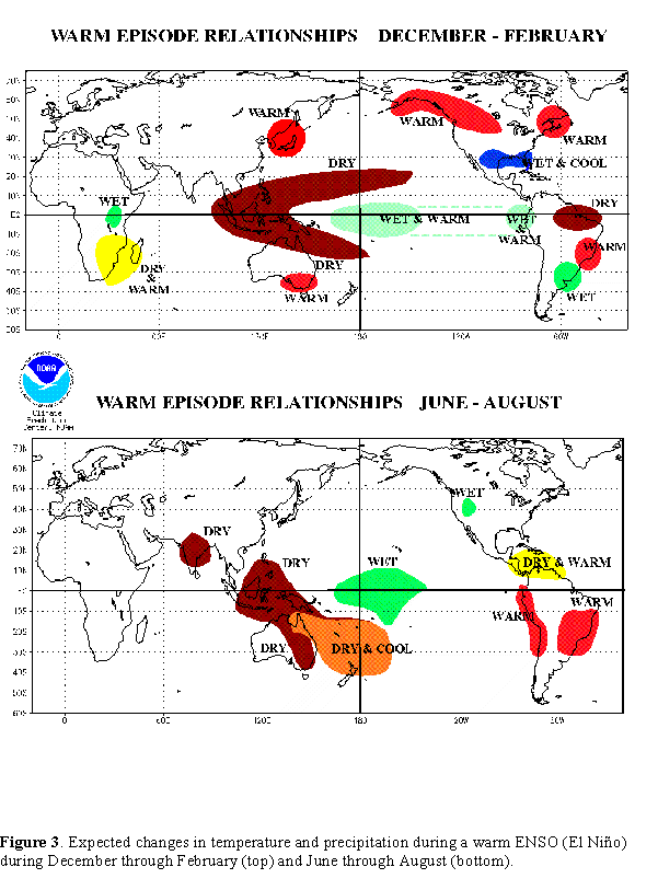
The shift in the distribution of winds, surface temperatures, and tropical convection leads to changes in the atmospheric circulation with the possibility of regional droughts, floods, and temperature changes in areas well beyond the tropical Pacific. The typical dependence for El Niño is shown in Figure 3 for Northern Hemisphere winter and summer. In northern middle latitudes, the strongest relationship occurs in the Northern Hemisphere winter when the atmospheric circulation is strongest. The figure shows that El Niño tends to cause warmer than normal winter temperatures in the U.S. Pacific northwest and higher than normal winter precipitation along the U.S. Gulf Coast. La Niña generally impacts the same areas as El Niño but with opposite effects. The ENSO cycle is rooted in the instability of the coupled atmosphere-ocean system. The instability produces repetition of an irregular, quasi-periodic cycle which varies between three and seven years.
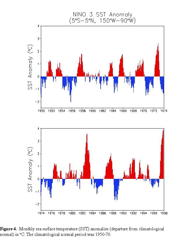
The ENSO research effort includes studies on the evolution of sea surface temperatures (SST) as part of the oceanic response to atmospheric forcing and meteorological studies on regional and large-scale air-sea interactions. Thus, monitoring and prediction of sea surface temperatures is an important part of monitoring and predicting ENSO. SST anomalies for 1950 to present are shown for a region with strong ENSO variability (10° N-10° S, 150° W-90° W) in Figure 4. The anomalous SSTs shown here are computed as the difference between measured monthly SSTs and the normal expected monthly SSTs for the period 1950-79. The figure shows positive and negative SST anomalies. Although the distinction between normal, El Niño, and La Niña is not rigorously defined, SSTs which persist for at least six months above roughly 0.75° C can be considered to indicate El Niño, while those that persist below -0.75° C can be considered to indicate La Niña. The figure also shows an overall warming of the tropical ocean by 0.5° C in the decades of the 1980s and 90s with stronger El Niño episodes occurring in the latter part of the record. The strongest complete El Niño occurred in 1982-83. However, if current predictions are validated, the present El Niño episode may become even larger and persist into 1998, which has been designated the Year of the Ocean.
ENSO (El Niño and La Niña) episodes cause changes in the normal global atmospheric circulation. The changes lead to changes in precipitation and temperature which strongly depend on season and location as shown in Figure 3. Areas that are strongly impacted during Northern Hemisphere fall and winter are the south of Africa, Australia, South America, and the U.S. The occurrence of El Niño or La Niña does not guarantee a specific precipitation or temperature response, but only increases the likelihood that a deviation from normal will occur.
Although crop yields depend on many factors, rainfall during part of the growth cycle is often critical. Despite the uncertainties, links between both El Niño and La Niña and crop yields have been established in a number of regions. As an example, winter crop yields in Texas, Oklahoma, Kansas, and Colorado show that the presence of El Niño, with its likelihood of increased rainfall, can increase yields by 15 percent, while La Niña, with its likelihood of decreased rainfall, can decrease yields by 15 percent.
G-9
G-10
G-11
During normal years, winds along the equator and along the coast of Peru and the west coast of North America, push surface waters offshore bringing cold, nutrient rich waters from below to the surface¾ a process known as upwelling. These cold, nutrient rich waters stimulate plant growth resulting in well-established plankton populations and the species which feed on them that include fish, birds, and marine mammals. During El Niño periods, the winds change, upwelling decreases, and the normal plankton population decreases. The animals which feed on the plankton either move elsewhere or die. For example, the 1972-73 El Niño coupled with overfishing caused a collapse of the anchovy fishery off Peru. In addition, in the Pacific northwest, El Niño leads to changes in the salmon fisheries. This is linked to more northward migration of mackerel which prey on juvenile salmon.
ENSO episodes can now be predicted to a level of skill and with enough lead time that hundreds of millions of dollars a year can be saved both in the U.S. economy and abroad. A recent interdisciplinary study estimated the value of improved ENSO forecasts to U.S. agriculture to be between $240 and $325 million per year. A draft study estimates the benefits of a perfect forecast in crop storage to be $240 million annually for corn alone. Advanced knowledge of ENSO will allow farmers to make decisions to maximize agriculture yields. ENSO forecasts have the potential to improve fisheries management because ENSO episodes strongly influence marine catches from Chile to Alaska. In addition, ENSO-induced changes in precipitation can lead to increases in the threat of mosquito-borne diseases such as malaria. The U.S. Centers for Disease Control and Prevention and the World Health Organization are building programs to utilize climate forecasts for enhanced health surveillance and early-warning systems.
Benefits to the water resources and energy sectors are potentially large. The availability of fresh water for irrigation and household use is fundamental to economic well being and varies dramatically during ENSO episodes. ENSO episodes have been linked to regional droughts and an increase in the number of forest fires due to decreased precipitation. Decisions on the purchase and distribution of fuels could be made more cost effective, or estimates of fuel demand based on anticipated climate trends could contribute to more efficient decisions regarding options for purchasing different energy supplies.
To produce useful seasonal to interannual climate forecasts, it is necessary to implement an operational climate forecasting system. It is also necessary to continue to invest in process and modeling research that leads to improved predictability of temperature and precipitation. In addition, enhanced global observing and data processing systems will continue to be required to support the research and to initialize and validate model predictions.
Status of the Relevant Science and Technical Base
Because of limited observational capabilities before the 1980s, it was not even possible to know if an El Niño episode was underway until several months after the episode began. Progress in climate prediction in the 1980s and early 1990s has been stimulated by the development of models used for ENSO prediction, by empirical and theoretical studies to better understand
G-12
the global impact of ENSO studies, and by the establishment of an ocean observing system (primarily in the Pacific) for initializing and verifying models for ENSO prediction.
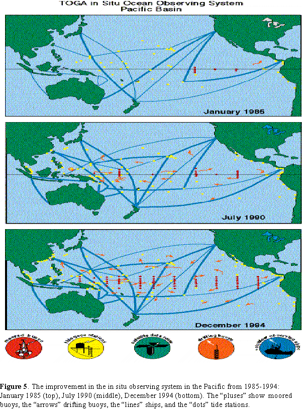
The in situ observing system in the Pacific Ocean improved dramatically during the 1985-94 Tropical Ocean Global Atmosphere (TOGA) period (see Figure 5). The most important component of this system is the National Oceanic and Atmospheric Administration (NOAA) Pacific Marine Environmental Laboratory (PMEL) Tropical Atmosphere Ocean (TAO) moored buoy array which provides basin-wide real-time measurements of surface and subsurface ocean temperature and surface atmospheric winds. These data are augmented by other in situ observations of these same quantities plus additional variables such as upper level atmospheric winds, sea level, and sea level pressure. In addition, remotely sensed observations systems from geostationary and polar environmental satellites give true global coverage of many atmospheric and oceanic variables. The present observing system is a fully multinational effort which is supported by more than two dozen countries.
Models used in ENSO prediction range from purely statistical models to fully coupled dynamic ocean-atmosphere models. Most of the experience in dynamical forecasting is based on an intermediate class of models which simulate only climate differences from normal in order to avoid problems with model climate drift. Some of the simpler models do not make full utilization of all the available data. The more complex coupled general circulation models make better use of the available data and are producing superior ENSO forecasts.
Many developing countries are strongly affected by ENSO episodes because their economies are dependent upon agricultural sectors as a major source of food supply, employment, and foreign exports. In these countries, droughts predicted up to several months in advance, coupled with the response of local farmers, have already contributed to maintenance of food supplies. For example in the Brazilian state of Ceara, agricultural officials used the predictions of the 1991-92 EL Niño to change the timing and types of crops planted. That year Ceara had harvests at near normal levels compared to the massive crop failures experienced during the 1986-87 El Niño.
For procedures such as these to work, it is desirable to have full and open access to data and analysis products among all participating nations, organizations, and institutions. In some cases, national security interests restrict the exchange of information. Moreover, a weakness of ENSO investigations is the limited cooperation among interdisciplinary groups. For example, coupled ocean-atmosphere models include analyses of ocean temperature, salinity, and currents. These data fields would be useful to biologists who wish to understand impacts of ENSO on the distribution of marine species.
The Tropical Ocean Global Atmosphere Program concentrated on ENSO with great success. However, other interannual signals in other tropical oceans and at high latitudes were ignored. For example, changes in the tropical Pacific account for only part of the variability observed over North America in temperature and precipitation. There are also emerging efforts to understand the variability and predictability of the American and the Asian-Australian monsoon
G-13
G-14
systems, the predictive air-sea interactive signal in the Atlantic known as the North Atlantic Oscillation, and decadal and longer climate variability.
Techniques and Arrangements for Managing Seasonal to Interannual Climate Impacts
NOAA, through the Climate Prediction Center of the National Centers for Environmental Prediction, currently provides operational seasonal forecasts based on a combination of dynamical model and statistical predictions for the U.S. for up to one year. NOAA actively coordinates its efforts with other federal agencies, principally NSF, NASA, and DOE. In addition to the federal agencies, the global nature of the climate signal requires involvement with universities and international agencies. These partnerships remain essential to develop the practical benefits of ENSO forecasts, and to move toward the understanding and prediction of other forms of climate variability.
Research programs are being developed to extend the predictability of ENSO and the accompanying oceanic and meteorological effects. These programs include the Global Ocean Atmosphere Land System Program which extends the original research effort begun by the Tropical Ocean Global Atmosphere Program, and the Global Energy and Water Cycle Experiment Program which improves the parameterization of water and energy fluxes in coupled air-ocean-land models.
A multinational Seasonal-to-Interannual Climate Prediction Program (SCPP) was designed to provide reliable forecasts and analyses of climate variations on seasonal to interannual time scales, and to develop the infrastructure by which this information can be used. The goal of SCPP is to take the next step toward reliable forecasts and analyses of climate variations on seasonal and interannual time scales, and to develop the infrastructure by which this can be used for social and economic benefit by all countries of the world. The program would initially focus on forecasting ENSO and the related climate impacts (atmospheric circulation, precipitation, and surface temperature), and will expand based on the results of continuing research.
A key component of the SCPP plan is the development of an end-to-end forecasting system to develop, improve, and transfer climate modeling technology from research centers to other centers which routinely produce and disseminate climate forecasts to affected local communities and local decision makers. This includes the establishment of an International Research Institute for Climate Prediction. This institute has the responsibility for generating and distributing experimental forecasts multinationally. The forecast information will be tailored to the specific area and take into account climate conditions, forecast needs, and interests as indicated by local decision makers and managers.
Issues Pertaining to Education and Human Resources
A major focus of climate research is the development of an informed and responsible citizenry who are knowledgeable about climate variability. This includes assessing the impacts of
G-15
climate variability on human activity and economic potential, and improving public education so climate forecasts are understood and used.
Societies from around the world could benefit by participating in a shared multinational mechanism to maintain and enhance predictability, and learn how to incorporate the information into decision making for broad based environmental and economic gain. Note that on a basic level, activities such as agriculture, fishing, water management, and fuel distribution must take into account the climatological mean annual cycle ¾ crops are planted in anticipation of the optimal growing season, fishing vessels in Peru and Oregon are readied for the seasons when wind-driven upwelling provides nutrients for the food chain; reservoir levels are lowered in anticipation of spring flooding; fuel oil is distributed in anticipation of wintertime heating needs.
Options for Consideration
The best understood and strongest interannual air-sea climate signal comes from ENSO which originates in the tropical Pacific and leads to changes in the atmospheric circulation well beyond the tropical Pacific. ENSO episodes can now be predicted to a level of skill and with enough lead time that hundreds of millions of dollars a year can be saved both in the U.S. economy and abroad.
NOAA currently provides operational seasonal forecasts based on a combination of dynamical model and statistical predictions for the U.S. An International Research Institute has been established to provide forecasts to other nations. For these efforts to succeed, it is necessary to continue to invest in process and modeling research and to enhance the global observing and data processing systems. It is also necessary to continue to study other interannual signals in the tropics and in higher latitudes. In addition, institutionalized systems, such as the International Research Institute, must continue to be supported so that national and international forecasts, as well as other climate services, can be continued and expanded as predictability of ENSO and other interannual signals improves. The development of new forecasting products that can be used for economic, disaster preparedness, and other planning purposes would also be very beneficial to the nation.
DECADAL TO CENTENNIAL CLIMATE IMPACTS
Introductory Considerations
Both the atmosphere and the ocean act together as a giant heat engine with the ocean also playing the role of a flywheel in the system. It takes approximately 4 years for the surface currents of the world’s ocean bodies to circulate around the globe. As they do so, they give up their heat to their surroundings and cool. These relatively warm currents also tend to have a slightly higher salt content than the waters they circulate through. This is due to increased evaporation at low latitudes resulting in a small increase in the concentration of salt. In certain parts
G-16
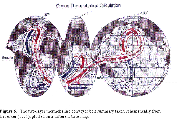
of the globe, these waters can cool sufficiently such that the colder temperatures combined with this higher salt content make them denser than the surrounding fresh waters. When this happens, this cold, dense water sinks and enters into the circulation of the deep ocean. The deep currents of the ocean eventually surface, primarily in the North Pacific, where they enter into the surface circulation again. It takes on the order of 700-1,000 years to complete a single circuit of the global ocean (see Figure 6, the "Conveyor Belt").
The ocean is not only an immense reservoir of heat and water but also of carbon dioxide (CO2). On geological time scales, marine biological processes act through the uptake of dissolved CO2 (photosynthesis) and its conversion to inorganic carbonate (which is precipitated as carbonate rock (limestone)) as the major control on CO2 distributions in the Earth’s biogeochemical system. On time scales of years, marine biological systems, as with faster growing terrestrial systems, equilibrate fairly rapidly with carbon dioxide in the atmosphere. On
longer time scales, transfer of CO2 to woody vegetation, soils, and transfer to the deep ocean removes CO2 from the atmospheric system. The oceanic sink of CO2 is considerably larger than the terrestrial sink. While 10-20 percent of the CO2 emitted to the atmosphere by man’s activities has been sequestered by terrestrial processes, some 40 percent of the total CO2 emitted by man has been removed from the atmosphere relatively permanently by oceanic processes.
Increased confidence in understanding climate variability, and potential impacts by man on climate can only be obtained through improved representation of ocean climate processes in models, and systematic collection of long-term instrumental observations of climate system variables in the ocean. Key uncertainties limit our ability to detect and project future climate change. In particular, the IPCC 1995 report lists the following as priority topics:
These priorities recognize that predicting climate change resulting from emissions of greenhouse species and formulating future decisions on the possible regulation of these emissions require more accurate models, models which have been adequately tested against a well-designed network of observations. Observations also serve other purposes. Of paramount importance, only observations can detect climate change. In addition, observations can provide increased understanding of climatically important ocean processes. Finally, chemical and physical oceanographic observations provide data needed to separate anthropogenic from natural variability.
G-17
G-18
Status of the Relevant Science and Technical Base
The ocean interior has a huge capacity to transport and sequester heat, fresh water, and CO2 exchanged with the atmosphere at the sea surface. Ocean transports of these play a large role in the present climate and its variability. Coupled ocean-atmospheric models used to predict global temperature changes have shown that the ocean sequestration has the potential to delay the impact of greenhouse gas emissions and thus affect changes in atmospheric conditions. These latter changes occur both directly by the oceanic uptake of 30-60 percent of the anthropogenic CO2 currently produced, thereby attenuating the atmospheric CO2 increase, and indirectly by buffering the atmospheric temperature increase due to the ocean's large thermal mass.
The present state of models and sparse observations are factors that lead to uncertainties in estimates of oceanic transport, uptake and sequestration. For example, the current coupled General Circulation Models (GCMs) used to simulate climate change fail to produce long-term trends in Pacific sea-surface temperature. Observationally, three estimates of the transport of heat from south to north at 24° N in the Atlantic show a steady rise from 1957 through 1992. Available data can not resolve if these changes represent a natural or an anthropogenic induced trend and/or whether they are biased by an unresolved annual signal. Furthermore, the uncertainty in ocean dissolve inorganic carbon uptake is 40 percent of the total (2.0 billion metric tons of carbon per year). These uncertainties must be reduced if confidence in CO2 warming scenarios is to increase.
Models complemented by observations provide the means to distinguish between natural variability on decadal to centennial time-scales and anthropogenic climate change. For example, a recent modeling study looked at a long term record of observed and simulated atmospheric temperature and found the rates of recent increases in temperature in both data sets to be similar. These rates are unprecedented in terms of the longer model record suggesting that the recent increases could be related to CO2 effects.
An effective approach to improve the representation of climatically important ocean processes in models is to test hypotheses on the dynamics of naturally occurring, coupled air-sea interactions that are found in models and observations. Several candidate hypotheses exist. For example, a model forced only by seasonally varying solar radiation at the top of the atmosphere includes coupling on decadal time scales between two atmospheric patterns¾ a connection between the Pacific and North America known as the PNA pattern and a North Atlantic pattern known as the North Atlantic Oscillation (NAO)¾ and the upper layers of the northern hemisphere middle latitude ocean. The NAO is a seesaw pattern in sea-level pressure with nodes over the Bermuda High and Icelandic Low. Both atmospheric features have been shown to have significant impact on U.S. and European climate on many time scales. On decadal time scales this could mean multiple years of weather regimes, like drought in the Southwestern United States or floods in the South Atlantic states. Observational studies of coupled air-sea interactions using recently collected data find similarities between the measurements and the coupled model results on decadal time scales in both the North Atlantic and Pacific basins. However, the
G-19
comparison studies are still at an early stage and validation of this coupled mode requires additional effort.
Results from another numerical model suggest that on multidecadal time scales, the NAO is coupled to the thermohaline circulation of the Atlantic. (Thermohaline circulation refers to circulation driven by density differences in the water with density being determined by temperature and salt content.) Recent observations also show that the decadal signal in upper layer temperature and NAO index are both superimposed on longer term trends. In addition, analysis of historical atmospheric data indicates that a strong decadal signal in NAO variability is limited to the past 30 to 40 years.
Recent model results from the Geophysical Fluid Dynamics Laboratory (GFDL) suggest the existence of a mode of climate variability on a multidecadal time series involving interactions between the Arctic and North Atlantic. This mode is characterized by variations in the export of fresh water and sea ice from the Arctic. It has substantial impacts on the atmospheric circulation and climate over parts of Europe, as well as on the intensity of the thermohaline circulation and associated meridional heat transport in the North Atlantic. Analyses of observations and various model runs with and without CO2 increases provide data for: (1) increased understanding of the dynamics of the coupled ocean atmosphere system; (2) identification of climatically important oceanic features to monitor; (3) model validation; (4) predictability studies; and (5) separation of natural and anthropogenic climate change. For example, observations can be used to benchmark decadal and multidecadal variability from model simulations. If the models provide realistic results of recent variability, this will offer confidence to conduct long simulations and assess the role of CO2 on the air-sea system.
Recent observations in the Atlantic argue for hypothesis driven climate studies in this basin. After decadal increases in the NAO index, a significant decrease in this pattern has just occurred (with expected changes in European weather). Concurrent with the increase in the NAO index, extrema in several properties of the thermohaline circulation in the Atlantic have been observed (e.g., convection in the Labrador Sea and lack of convection in the Greenland Sea, increased subsurface temperatures in the subtropical Atlantic, and recently ventilated waters observed in the deep currents along the western boundary of the North Atlantic Ocean).
Several data-sets have been collected and several observing networks are in place that provide a critical foundation for detection of climate change. The NOAA/DOE/NSF supported World Ocean Circulation Experiment hydrographic program and global carbon survey have provided an accurate benchmark for the ocean inventory of CO2 and other properties. Comparisons of these data with historical records are revealing large-scale variability in ocean properties over decadal time scales. Synthesis of these data will greatly improve estimates of interior ocean fluxes. Analysis of the CO2 survey data will yield robust estimates of the oceanic uptake of CO2 to date thereby offering critical constraints on partitioning of anthropogenic CO2 between the atmosphere, ocean, and terrestrial biosphere. Continued direct measurements are needed next to: (1) track the rate of change of oceanic CO2 and estimate CO2 fluxes (e.g., GCM's suggest that ocean sequestration of CO2 decreases in response to climate warming); (2) track
G-20
changes in the storage and fluxes of heat and freshwater; and (3) provide data for model validation studies.
Upper layer temperature data are collected, in part, by a global Volunteer Observing Ship network. This network provides over 100 years of surface data including SST and about 30 years of subsurface temperature data. Analysis of these data provided the characteristics of many of the decadal signals described above. There are, however, large areas, particularly in the central and eastern northern oceans and all of the southern oceans, where little or no data are available. Data sparsity in the northern hemisphere precludes validation of several of the theories described above. In the southern hemisphere, variability in water properties as large as those associated with the PNA pattern and NAO have been observed. Possible aliasing and other problems resulting from the sparse sampling in the region has made establishing dynamical mechanisms and air-sea feedback difficult. Trade-offs between in situ and remote sampling of upper layer characteristics in data poor regions must be evaluated to develop cost-effective network designs. Combinations of modeling and empirical network design efforts are an integral part of developing detection/attribution capabilities.
NOAA/OAR/ERL (Environmental Research Laboratories) are active in long term climate research ranging from data collection to data synthesis, and from model development to model validation. For example, the Atlantic Oceanographic and Meteorological Laboratory and the Pacific Marine Environmental Laboratory) are engaged in completing the global carbon survey directed at obtaining an accurate benchmark inventory of CO2, anthropogenic CO2 and other properties. In addition, the Atlantic Oceanographic and Meteorological Laboratory, the Climate Diagnostics Center, and the Pacific Marine Environmental Laboratory are involved in the Atlantic Climate Change Experiment, the last field phase of the World Ocean Circulation Experiment. This NSF/NOAA program is concerned with increased understanding of the role of the Atlantic Ocean in global atmospheric climate. ERL scientists are also involved in the synthesis of these data, bringing the diverse World Ocean Circulation Experiment and other data-sets into a comprehensive picture of the present state of the ocean. Attention is directed at air-sea and meridional ocean fluxes of carbon, heat, and freshwater, and the amount of anthropogenic CO2 sequestered in the ocean.
GFDL scientists are constantly improving coupled GCMs to study natural decadal to centennial climate variability and the effects of different CO2 scenarios. Recent activities have included: (1) The development of coupled models with higher computational resolution, leading to substantial improvements in the simulation of interannual to decadal climate variability; (2) fundamental improvements in the representation of sub-grid scale processes in ocean models; and (3) the simulation of the climate response to estimates of the time-varying radiative forcing of the Earth over the last 200 years. GFDL model results and results from other modeling centers are being compared to observations by all four ERL groups. The model-data comparisons are not only leading to GCM improvements but also to increased understanding of both the coupled air-sea system and the predictability of this system.
G-21
Issues Pertaining to Education and Human Resources
The Earth’s climate system is extremely intricate. Clouds, ocean currents, solar radiation and other elements interact in a complex way to determine our climate. Mathematical models allow us to study parts of the climate system and how those parts interact. Even though these models include many aspects of the climate system (air, oceans, land, biology) partitioned into many small grid boxes, and may require weeks of powerful computer time to run, they are relatively simple when compared to the natural system. The models indicate that temperature could rise considerably over some areas of the globe due to increased emissions of greenhouse species. The issue is one of how accurate are these predictions.
Despite their complexity, current models do not adequately represent the roles of the ocean and clouds in the climate system. These models do provide useful insights into the climate system. When attempting to make conclusions regarding long-term climate variability, these models require decades of precise observations to verify. Only now are we approaching possessing a long enough record of precise data to make some preliminary assessments regarding model predictions. Unfortunately, the long periods involved in the oceanic response and the large inertia of the ocean mean that any actions taken to reverse impacts of man on long-term climate will require decades to centuries before significant impacts could occur.
Summary
Observations describe variations in the climate system, whereas models provide a mechanism for understanding why such variations occur and for predicting the future evolution of the climate system. A three-pronged program of integrated research has been used to improve representation of climate processes in models and to collect long-term instrumental and proxy observations in the oceans: (1) retrieval and analysis of instrumental and paleoclimate data to develop the long data-sets needed for detection studies and to test hypotheses and develop sampling strategies; (2) collection of new data for continued detection efforts based on analyses and weaknesses of the historical data; and (3) model studies using historical and new data to validate and initialize simulations and perform attribution studies. The benefits to society of this approach are: (1) improved detection of climate change signals in the ocean; (2) improved models of natural and anthropogenic climate variability; (3) quantification of the predictability of long-time scale climate variability; and (4) reduced uncertainties in CO2 warming scenarios.
Options for Consideration
In order to better understand the changes in the earth’s climate and what types of impacts would occur, the following suggestions are offered:
G-22
GLOBAL CLIMATE CHANGE IMPACTS ON U.S. COASTAL AREAS
Introductory Considerations
The United States has one of the longest and most diverse coastlines in the world—about 158,000 kilometers (95,439 miles) of tidal shoreline in coastal areas and the Great Lakes—and with characteristics as different as the locations of Alaska, Florida, California, and American Samoa. About 94,400 kilometers (59,000 miles) of this shoreline lie around the conterminous United States, bounding some of the most valuable and heavily used coastal areas in the world that could be affected by climate change. Within these coastal areas lie about 38,900 square kilometers (15,000 square miles) of coastal wetlands and 6,500 square kilometers (2,500 square miles) of developed barrier islands. The wetlands provide habitat for numerous species of birds, are a nursery ground for many commercial fish and shellfish; play a vital role in extracting nutrients and toxic chemicals from water; and provide a buffer against coastal storms. The developed barrier islands are primarily recreational communities.
U.S. coastal areas support a variety of important economic activities, including fisheries and aquaculture, tourism, recreation, industry, and transportation. Coastal fisheries, for example, produce about $3 billion in revenue to fishermen and generate $38 billion in economic activity nationally per annum. Seventeen million Americans who enjoy recreational fishing, generate an estimated $18 billion in economic activity. Over 85 percent of travel and tourism revenues are generated in coastal states. In Hawaii, seven million tourists generate $9.1 billion in revenue, and in Florida, 21.6 million tourists spend $7.9 billion and generate over 360,000 jobs mainly due to the attraction of Florida’s coasts.
Current Stresses on Coastal Resources
U.S. coastal areas are experiencing greatly increased pressures as a result of rapid population growth and accompanying development. Population growth in U.S. coastal areas is higher than anywhere else in the country. At present, more than 50 percent of the population lives within 130 kilometers (80 miles) of an ocean or Great Lake and population densities within U.S. coastal areas are five times the national average.
The effects of climate change would add to stresses that already affect coastal areas. An estimated 40 percent of estuarine and coastal waters is not "fishable or swimmable," primarily because of nutrients and bacteria from urban and agricultural runoff and municipal wastewater
G-23
treatment discharges. About 40 percent of over 20 million acres of shellfish-growing waters in estuaries are "harvest-restricted," i.e., commercial harvest is either prohibited or limited, due primarily to bacterial contamination from urban and agricultural runoff and septic systems. In addition, the effects of pollution, as well as changes in salinity and hydrology have contributed to the loss of traditional shellfish acreage that can no longer support shellfish along U.S. coasts. These changes would be exacerbated by climate change. During 1996, at U.S. ocean, bay, and Great Lakes beaches, there were at least 2,596 individual closings and advisories, 16 extended (6-12 weeks) closings and advisories, and 20 permanent (over 12 weeks) closings and advisories. Including the days of extended closings, the total comes to over 3,685 closings and advisories (NRDC, 1997). U.S. shorelines are undergoing erosion from sea-level rise, natural retreat of headlands, coastal structures, and modifications to the natural flow of rivers.
Human activities from further inland can also have a deleterious impact on coastal resources. Effluent discharges from sewage and industrial plants, as well as agricultural run-off, have caused significant nutrient over-enrichment in many coastal waters. Sewage and siltation can be significant causes of coral reef and other coastal system degradation in Hawaii and Florida. Dams, irrigation projects, and other water control efforts have affected coastal environments by diverting or altering the supply of water, sediment, or nutrients to a naturally balanced ecosystem.
Intensive residential and commercial development of coastal areas, particularly dynamic, storm-prone areas such as barrier islands, puts life and property at risk and creates substantial financial liabilities. For example, there are currently an estimated 276,000 households located in high-hazard areas threatened by storm surge, and an additional 2.4 million households located in the flood plain adjacent to this high-risk zone. In addition, between 1970-89, almost half of all new residential, commercial, and industrial construction occurred in coastal counties and was not always built to standards to withstand major storms. Infrequent, yet high intensity storms that impact coastal areas, in conjunction with poor construction, can result in billions of dollars of damages, particularly where development occurs in low-lying areas. The cost of damage from Hurricane Andrew (in Florida and Louisiana) was $25 billion, and the combined costs for Hurricanes Hugo (South Carolina), Opal (Florida), and Fran (North Carolina) totaled $3 billion. While a majority of damage from these storms was due to poor construction of infrastructure and buildings, costs from coastal storms could be reduced or prevented by making better decisions about the location and type of development in coastal areas.
Key Strategic Issues Concerning Coastal Areas and Climate Change
Throughout time, climate change has affected the coastal environment and will continue to do so in the future. However, human activities and alterations have rendered coastal resources more vulnerable to climate change-induced processes, such as accelerated sea-level rise, alterations of rainfall patterns and storm frequency or intensity, and increased siltation. Climate change and a rise in sea level or changes in storms or storm surges could result in the increased erosion of shores and associated habitat, increased salinity of estuaries and freshwater aquifers, altered tidal ranges in rivers and bays, changes in sediment and nutrient transport, a change in the
G-24
pattern of chemical and microbiological contamination in coastal areas, and increased coastal flooding.
Some coastal ecosystems are particularly at risk, including saltwater marshes, coastal wetlands, coral reefs, coral atolls, and river deltas. Other critical coastal resources, such as mangroves and sea-grass beds, submerged systems including submerged aquatic vegetation , and mudflats, are at risk from climate change impacts, and exacerbated by anthropogenic factors. Changes in these ecosystems could have major negative effects on tourism, freshwater supplies, fisheries, and biodiversity that could make coastal impacts an important economic concern. These impacts would add to modifications in the functioning of coastal oceans and inland waters that already have resulted from pollution, physical modification, and material inputs due to human activities. Secondary impacts associated with climate change, such as inundation of waste disposal sites and landfills that in turn will reintroduce toxic materials and increased siltation into the environment, also pose threats to the health of coastal populations and ecosystems.
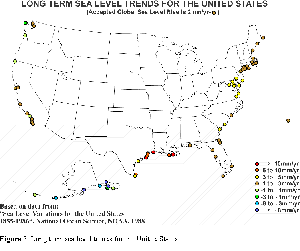
Global sea levels have been rising since the conclusion of the last Ice Age approximately 15,000 years ago. During the last 100 years, sea-level rise has occurred at approximately 1-2.5 mm/yr. This figure represents eustatic sea level (the absolute elevation of the Earth’s ocean) that has been determined from tidal stations around the globe. However, there are large regional variations due to: subsidence, isostatic (glacial) rebound, tectonic uplift, etc., that contribute to a "relative" sea-level rise. For example, within the U.S., portions of the Gulf Coast are experiencing a relative sea-level rise of 10 mm/year. Concurrently, the coast of Alaska is experiencing a negative relative sea-level fall of up to 8 mm/year; i.e. sea level is receding. Figure 7 illustrates the change in sea level along U.S. coasts as determined from historical tidal data. If this historical rate of sea-level rise is projected to 2100, sea level would rise 10-27 cm globally. A recent EPA study assessed the probability of sea level rise along various U.S. coastal towns and estimated that there is a one percent change of a 120 cm rise and a 50 percent chance of a 55 cm rise in sea level by the year 2100 along the New York coast.
Rising global temperatures could further raise sea level by expanding ocean water, melting alpine and other small glaciers, and perhaps eventually causing the polar ice sheets of Greenland and Antarctica to melt into the oceans. The most recent IPCC assessment (1995)
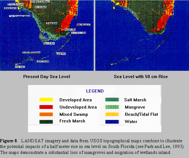
forecasts a rise in global sea level of 5 mm/year, within a range of uncertainty of 2- 9 mm/year with almost all of the contribution resulting from thermal expansion and melting small glaciers. The IPCC predicts low, mid, and high estimates of 20, 49, and 86 cm. This current best forecast represents a rate of sea-level rise that is still about two to five times the rate experienced over the last 100 years. Furthermore, even if greenhouse-gas concentrations are stabilized, model projections show that sea level will continue to rise beyond the year 2100 due to lags in response to climate change. Figure 8 indicates the potential impact of a 50 cm sea-level rise, or approximately the mid-range IPCC estimate, in South Florida.
The IPCC estimates are based on the effects of thermal expansion of the ocean. They do not include the possible contribution that the melting of the Greenland and Antarctic ice sheets
G-25
G-26
G-27
would have on sea-level rise. While still debated and somewhat speculative, such melting would provide a much greater contribution to global sea-level rise.
Coastal land, including buildings, transportation infrastructure, and recreational and agricultural areas, is vulnerable to inundation and increased erosion as a result of climate change. All lowlands are threatened by a rise in sea level. Estuaries are also threatened by potential
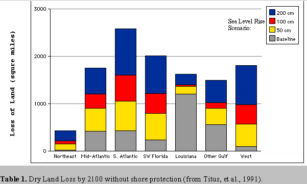
hydrologic changes that could increase the range of saltwater intrusion as well as alter the amount of freshwater reaching an estuary. If a one-meter rise in sea level occurs during the next century, the worst-case IPCC scenario, thousands of square miles could be lost, particularly in low-lying areas such as the Mississippi delta, where land is also subsiding at a rate of approximately one meter per century. Table 1 indicates the estimated land loss for seven regions of the United States. Storm damage is expected to also increase, particularly along the well-developed and low-lying Atlantic and Gulf of Mexico coasts.
Assessing total economic impacts from sea-level rise on coastal areas and on a national scale is still somewhat speculative. Nevertheless, a recent study has quantified the present value of the economic costs (protection plus abandonment) to coastal structures with a 1-meter sea-level rise as $6.4 billion between 1996 and the year 2100. However, this figure represents only market-valued estimates which are derived from property-value appreciation, market adaptation, and protection costs. Thus, it is a minimum cost estimate which does not include the lost service value of non-market resources, such as tidal wetlands. Estimates of impact on such resources are more difficult to quantify because they lie outside the traditional market and have not yet been thoroughly measured. Natural systems, like a tidal wetland, can provide flood control, storm protection, and waste recycling and have tremendous value when measured economically.
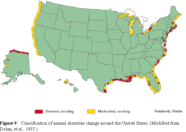
Coastal erosion is already a widespread problem in the United States. For example, in Oahu, Hawaii, over the past 50 years a quarter of the beaches have been lost or significantly degraded due to causes that are poorly understood. Heightened storm surge could increase the rate of erosion. The highest-risk areas are those with very low relief and currently experiencing rapid erosion rates, such as the southeastern United States and the Gulf Coast (see Figure 9). Coastal areas would also be more vulnerable to hurricanes, as well as to increased or decreased freshwater and sediment flux from river systems.
Rising sea-level will, in general, increase storm surge flooding by the level of sea-level rise, making every coastal storm appear more intense. However, some areas will experience dramatic changes—going from no flooding to extensive flooding. Many coastal features, such as levees, seawalls, and naturally occurring sand dunes and ridge lines effectively block storm surges for most storms. Whenever one of these features is overtopped by storm surge from either a hurricane or an extratropical storm, the areas inland will flood. Numerical modeling has shown that large amounts of water can move over such barriers, flooding over the marshland or bay behind the barrier, and sweeping over mainland areas.
G-28
G-29
G-30
Many coastal structures were designed with the 100-year flood as their basis. This flooding level determines the elevations to which the federal projects (such as U.S. Army’s Corps of Engineers levees that protect New Orleans) are built. It is also the level to which coastal structures must be built to qualify for flood insurance through FEMA’s Flood Insurance Program. If sea level rises, the statistics used to design these structures change. A 50-year flood may become as severe as (or even more severe than) a 100-year flood before sea-level rise. Coastal insurance rates would be adjusted to reflect such increased risk. Furthermore, FEMA estimates that with a sea-level rise of one meter, the number of households in the coastal floodplain would increase from 2.7 million to 6.6 million by 2100. This growth will be the result of sea-level rise as well as the increase of coastal population. In some areas however, structures will be upgraded as sea level rises so that flood risks will not increase.
Coastal wetlands are already eroding in most states (see Table 2), particularly Louisiana and Maryland. For example, Louisiana’s coastal area lost an estimated 3,950 square kilometers of wetlands from 1930 to 1990. This loss of wetlands resulted, for the most part, from flood-protection levees along the Mississippi and artificial bank stabilization efforts to confine the flow of the river and prevent the flooding, sedimentation, and freshwater supplies that occurred naturally. Many wetland losses elsewhere result from draining or filling. In addition, large areas of brackish and freshwater wetlands have become progressively more saline as salt water has increasingly invaded the deteriorating coastal zone. Because 40 percent of U.S. coastal wetlands are found in Louisiana, this loss constitutes about 80 percent of the total national coastal wetland loss. Louisiana coastal wetlands are exceptionally valuable in terms of coastal fisheries and migratory waterfowl, protection of low-lying population centers from hurricanes and other storms, and oil and gas production. Furthermore, the greatly accelerated rates of coastal wetland loss appear to be the unintended result of massive human disturbances of these wetlands and intervention (for purposes of flood protection, water supply, maritime commerce, energy production, and wildlife management) in the processes that sustain coastal wetlands.
Wetlands require a delicate balance of sediment, fresh and salt water and are particularly vulnerable to inundation and erosion as a result of sea-level rise. Coastal wetlands are also vulnerable to changes in the source or decreased flux of fresh water and sediment, if upstream areas become more arid. Wetlands naturally migrate as land subsides and sediment supply changes, but migration has been limited in several areas by the encroachment of urban areas which utilize sea walls and other protective structures. In addition, the possible rate of sea-level rise predicted by some climate change models is more rapid than the natural rate of wetland migration, thus wetland losses will likely increase.
Estuarine beaches are also at particular risk to sea-level rise. They are much more vulnerable than ocean beaches because they tend to be narrower and policies against shoreline armoring generally apply to oceans but not to bays. Also, they are more vulnerable than vegetated wetlands because the wetland protection programs tend to focus on the total area of wetlands protected and because beaches are narrow, they do not represent much acreage. The loss of these beaches would effect species such as horseshoe crabs and the birds that feed on them, as well as terrapins, least terns, and tiger beetles.
G-31
Table 2. Regional and National Wetland Losses for the Trend and 1.0 Meter Sea Level Rise Scenarios (percent loss of current area) (from Titus, et al., 1991).
| Current |
Trend |
1.0 Meter |
|||
| Region | Wetland Area (sq mi) |
___________________ |
_________________ |
||
| Standard(a) | Total(a) | Standard(a) | None(a) | ||
| Mid-Atlantic | 746 | -5 | 70 | 46 | 38 |
| South-Atlantic | 3814 | -2 | 64 | 44 | 40 |
| South/Gulf | |||||
| Coast of Florida | 1869 | -8 | 44 | 8(b) | 7(b) |
| Louisiana (c) | 4835 | 52 | 85 | 85 | 85 |
| FL Panhandle, | |||||
| AL, MS, and TX | 1218 | 22 | 85 | 77 | 75 |
| West (d) | 64 | -111 | 56 | -688 | -809 |
| United States | 13,145 | 17 | 66 | 49 | 50 |
| Confidence Intervals: | |||||
| 95% Low | -- | 9 | 50 | 29 | 26 |
| 95% High | -- | 25 | 82 | 69 | 66 |
| Note. | A negative number indicates a gain in wetlands. |
| a | Total protection refers to all shores being diked or bulkheaded; standard protection refers to only currently developed areas being protected. |
| b | Results are not statistically significant; sampling error exceeds estimate of wetland lost. |
| c | An evaluation of the management options currently contemplated for Louisiana (e.g. restoring natural deltaic processes) was outside the scope of this study. |
| d | This anomalous result is from small sample size. The impact on the nationwide results is negligible. |
G-32
Climate change also has the potential to significantly affect coastal biological diversity. It could cause changes in the population sizes and distributions of species, alter the species composition and geographical extent of habitats and ecosystems, and increase the rate of species extinction. Fragile systems such as coral reefs are highly susceptible to temperature increases. Short-term increases in water temperatures on the order of only 1-2° C, combined with other environmental stresses (such as pollution or siltation from human activities), can cause "bleaching," leading to significant reef destruction. Reefs in many parts of the world, including the United States, have undergone episodes of bleaching, particularly in the 1980s. Sustained increases of 3-4° C above long-term average seasonal maximums can cause significant coral mortality. Biologists suggest that full regeneration of these coral communities could require several centuries.
Fisheries in estuaries and the coastal ocean are also vulnerable to changes in water temperature and freshwater inflow. The loss of coastal wetlands has already been implicated in the decline of shrimp harvests in Louisiana, and would also likely reduce yields of crab and menhaden. Projections of general circulation models suggest that freshwater discharge from the Mississippi River to the coastal ocean will increase 20 percent if atmospheric carbon dioxide concentrations doubles. This is likely to affect water column stability, surface productivity, and global oxygen cycling in the northern Gulf of Mexico, which is already suffering from persistent hypoxia. In the open ocean, increased temperatures could result in a shifting of the geographical distribution of certain species. Decreasing freshwater flow, when combined with rising sea level could result in the encroachment of saltwater species into typically freshwater habitats. For example, in estuaries, decreased freshwater inflow could result in increased salinity and, in turn, a replacement of some freshwater species by saltwater species.
Management Issues and Strategies
Management strategies in coastal areas can be divided into three categories:
(1) Accommodate. Vulnerable areas continue to be occupied, accepting the greater degree of effects, e.g., flooding, saltwater intrusion, and erosion; advanced coastal management used to avoid the worst impacts; improved early warning of catastrophic events; and building codes modified to strengthen structures
(2) Protect. Vulnerable areas, particularly population centers, high-value economic activities, and critical natural resources, are defended by sea walls, bulkheads, saltwater intrusion barriers; other infrastructure investments are made; and "soft" structural options such as periodic beach re-nourishment, landfill, dune maintenance or restoration, and wetlands creation are carried out
(3) Retreat. Existing structures and infrastructure in vulnerable areas are abandoned, inhabitants are resettled, government subsidies are withdrawn, and new development is required to be set back specific distances from the shore, as appropriate.
G-33
The cost-effectiveness of these adaptation strategies is enhanced to the extent that they are planned and implemented in the context of integrated coastal management programs carried out at various levels of government.
Integrated coastal management is a continuous, iterative, adaptive, and consensus-building process comprised of a set of related tasks, all of which must be carried out to achieve a set of goals for the sustainable use of coastal areas, including adapting to the effects of climate change (Bower, Ehler, and Basta, 1994). The dimensions of integrated coastal management include:
At the federal level, agencies such as the U.S. Environmental Protection Agency have produced a number of studies which have begun to look at projected global climate change impacts on specific resources such as wetlands and to consider possible response options.
Individual states have used all three management strategies. Beach re-nourishment has been prominent in heavily developed areas (e.g., Miami, Florida and Ocean City, Maryland) where existing investments and the income generated by beach users is considered greater than the costs of the re-nourishment projects. Sea walls are often built to protect lives and property, but the trade-off is often the loss of usable beaches and other habitats. Most of these actions are taken to address current conditions and needs.
State and local government responses to future accelerated sea level rise scenarios include:
(1) taking accelerated sea-level rise into account when filling wetlands for water-dependent facilities (ports)¾ which requires an applicant to raise the fill level so facilities will not have to be abandoned during their 50-100 year life expectancy (San Francisco Bay Conservation and Development Commission);
G-34
(2) raising the elevation of new facilities such as sewage treatment plants to protect the integrity of the facility’s use (Massachusetts Water Resources Authority);
(3) incorporating sea-level rise into setback laws for larger facilities which goes beyond the normal incorporation of only historical rates of erosion (Maine Coastal Zone Management Program);
(4) passing legislation in support of a retreat policy that normally prohibits sea wall construction to allow backward migration of a beach (North and South Carolina Coastal Zone Management Programs).
To support state coastal management efforts, the Coastal Zone Management Act was amended in 1990 to further encourage state efforts to incorporate the problems of climate change and sea-level rise into their programs under natural hazards.
In February 1997, the U.S. Country Studies Program and NOAA sponsored an international workshop in Chinese Taipei that developed guidelines for integrating coastal management and climate change adaptation strategies. These can serve as a guide for coastal nations to implement or strengthen an Integrated Coastal Management program, and simultaneously meet the obligations of international agreements.
Status of the Relevant Science and Technical Base
Continued investments in research and monitoring at the national and international levels are needed to improve the information base for adapting to climate change. For example, coastal wetlands naturally migrate in response to changes in sediment supply and relative sea level. However, it is unknown if the rate at which wetlands can naturally migrate is sufficient for the possible rates of sea-level rise that would be caused by climate change. Establishing locations for wetlands to migrate to by expanding reserves and protected areas adjacent to current coastal wetlands can facilitate adaptation. Creation or restoration of wetlands is another adaptive strategy that requires the development of effective methods for restoring coastal wetlands and for measuring the effectiveness of those restoration efforts.
The White House Committee on the Environment and Natural Resources (CENR) is currently coordinating several wetland activities¾ including studies of recent changes in wetland systems along the eastern Gulf of Mexico and southern Atlantic coasts, and studies of changes documented in the Mississippi Delta—which should establish credible limits on the ability of coastal wetlands to adapt to sea-level rise by vertical growth. Other Committee on the Environment and Natural Resources research related to the vulnerability and adaptation of coastal systems include space-based geodesy studies to distinguish the long-term trends in sea-level change due to glacial melting and ocean expansion from effects of post-glacial rebound and active tectonics; studies that test existing geological models of coastal erosion processes; and studies of the frequency, magnitude, and tracks of storms.
G-35
Internationally, the Intergovernmental Oceanographic Commission of UNESCO is coordinating the development of a Global Ocean Observing System (GOOS). This is an intergovernmental program for the collection, distribution, and exchange of marine and oceanographic data. One of its principal elements, the GOOS Coastal Module, is designed to integrate and facilitate access to in-situ and remotely sensed coastal observations for reliable assessment, prediction and management of coastal areas and resources.
The Global Coral Reef Monitoring Network is a major contribution to the GOOS Coastal Module. Co-sponsored by the IOC, United Nations Environment Programme and the World Conservation Union, the network’s goal is to improve the conservation, management, and sustainable use of coral reefs and related coastal ecosystems by providing data and information on trends in their biophysical status and the social, cultural, and economic values that pertain to these ecosystems.
Two major international climate change assessments (1990 and 1995) have been conducted by the Intergovernmental Panel on Climate Change (IPCC), which was established by the World Meteorological Organization (WMO) and the United Nations Environment Programme (UNEP) in 1988. These assessments examined the available science, the magnitude of human-induced climate change, and appropriate response options. Some areas that require further scientific research and data include scaling down of current general circulation models to obtain local climate change estimates, as the current GCM resolution is too low. In addition, sea-level rise alone is not an exclusive feature of climate change in coastal areas. Therefore, climate change studies need to be broader, combining the effects of sea-level rise, storminess, atmospheric circulation change, precipitation, etc.
The IPCC 1995 assessment indicates that more work is necessary for quantifying the social costs of climate change. Net climate change damages include both market and non-market impacts and, in some cases, adaptation costs. However, the non-market damages (e.g. human health, risk of human mortality and damage to ecosystems, etc.) are highly speculative and not comprehensive, and therefore are a source of major uncertainty in assessing the implications of global climate change for human welfare.
Legal Framework
The United States is a Party to the Framework Convention on Climate Change that entered into force in 1994. Its major objective is to achieve the stabilization of greenhouse gas emissions and to identify national adaptation strategies. Article 4 of the Convention commits nations to, among other things, develop integrated plans for coastal zone management as part of their adaptation strategies. In response to potential commitments and obligations under the United Nations Framework Convention on Climate Change, many nations, including the U.S., are preparing national climate change action plans that identify management strategies to reduce greenhouse gas emissions. Although the United States is not currently developing a plan for adapting to the potential impacts of long-term climate change, such plans could be developed within the framework of existing laws.
G-36
Any plan for adapting to sea-level rise must consider federal, state, and local legislation. Under the common law of most states, tidal waters up to mean high water are owned by the public. As sea level rises, the boundaries of land ownership generally migrate inland, under state law. State laws vary considerably both on whether property owners must allow the shore to retreat or are allowed to erect protective measures. At one extreme, Texas and Maine prohibit structures that protect property at the expense of narrowing the beach; at the other extreme, Maryland’s Tidal Wetlands Act guarantees the right to erect structures to hold back the sea.
Responses to sea level rise also depend on the type and density of development near the shore. In most states, local master plans and zoning laws govern land use, although state coastal zone management laws also play a role. Maryland’s Critical Areas Act and New Jersey’s Coastal Area Facilities Review Act severely restrict the density of development in portions of their coastal zones. Several states have setback laws requiring new structures to be a minimum distance from the shore. Although water pollution and existing erosion hazards were the primary impetus for these laws, they also provide a framework for a response to sea-level rise. Setbacks are consistent with a presumption that shores will retreat naturally. The Maryland and New Jersey statutes are consistent with a presumption that densely developed areas will be protected, while shorelines in undeveloped areas remain in their natural states.
State laws on access to the shore also influence a states ability to address rising sea level. Along ocean shores with ample public access, such as New Jersey and Florida, public support for beach re-nourishment and shoreline planning to maintain beaches tends to be great. Along shores with little public access, especially bay shores, the constituency for preserving natural shorelines tends to be less significant.
Several federal statutes address coastal problems related to rising sea level. Section 10 of The Rivers and Harbors Act and Section 404 of the Clean Water Act have created a federal program of wetland protection. Strictly speaking, federal jurisdiction only extends up to the upper boundary of the wetlands. Nevertheless, EPA and the Corps of Engineers have the discretion to consider sea level rise and other environmental issues in the administration of wetland mitigation programs in which, for example, a landowner is permitted to eliminate a strip of wetlands in return for protecting or creating wetlands elsewhere. The Federal Flood Insurance Act provides a comprehensive framework by which coastal communities attempt to limit the vulnerability of property to floods. Although the guidelines under which the program operates do not explicitly consider sea-level rise, they influence the vulnerability of coastal development to rising sea level. As with the wetland legislation, the executive branch has the administrative discretion to modify existing guidelines to prepare for rising sea level should it decide to do so.
Perhaps the most important federal statute for addressing sea-level rise is the Coastal Zone Management Act (as amended by Public Law 104-150). The Act provides a comprehensive framework within which all coastal problems can be addressed. In reauthorizing the Act in 1990, Congress recognized the importance of this potentially new threat to the nation’s shoreline environments and encouraged coastal states and territories to begin to address rising sea level as noted in the following sections:
G-37
Congressional Findings: SEC. 302. The Congress finds that...
(l) Because global warming may result in a substantial sea level rise with serious adverse effects in the coastal zone, coastal states must anticipate and plan for such an occurrence.
Congressional Declaration Of Policy: SEC. 303. The Congress finds and declares that it is the national policy
(2) to encourage and assist the states to exercise effectively their responsibilities in the coastal zone through the development and implementation of management programs to achieve wise use of the land and water resources of the coastal zone, giving full consideration to ecological, cultural, historic, and esthetic values as well as the needs for compatible economic development, which programs should at least provide for...
(B) the management of coastal development to minimize the loss of life and property caused by improper development in flood-prone, storm surge, geological hazard, and erosion-prone areas and in areas likely to be affected by or vulnerable to sea level rise, land subsidence, and saltwater intrusion, and by the destruction of natural protective features such as beaches, dunes, wetlands, and barrier islands,...
(K) the study and development, in any case in which the Secretary considers it to be appropriate, of plans for addressing the adverse effects upon the coastal zone of land subsidence and of sea level rise; and...
(3) to encourage the preparation of special area management plans which provide for increased specificity in protecting significant natural resources,.. improved protection of life and property in hazardous areas, including those areas likely to be affected by land subsidence, sea level rise, or fluctuating water levels of the Great Lakes, and improved predictability in governmental decision making...
Many state Coastal Zone Management programs have used federal funds to conduct studies and develop policies to this end.
In addition to its role as a regulator and financial and technical assistance provider, the federal government also has the legal authority to address sea-level rise in its role as a property owner. Numerous parks and wildlife refuges are found along the coast. Under both federal and state law, the federal government has the authority to purchase easements to enable ecosystems to migrate, and to construct coastal protections structures to protect government property from the effects of erosion and storms.
G-38
Issues Pertaining to Education and Human Resources
Education, training, and outreach that target all sectors of society are essential components in the successful implementation of Integrated Coastal Management and climate change adaptation strategies. In July 1997, President Clinton launched a campaign to educate Americans about global warming and build support for the steps necessary to deal with it, including the United States agreement to binding reductions in greenhouse gases that were negotiated at the international conference on climate change during December 1997 in Kyoto, Japan. This led to a U.S. agreement for binding reductions in greenhouse gases that were negotiated at an international conference on climate change during December 1997 in Kyoto, Japan. However, as a July 21, 1997 article in the Washington Post pointed out, President Clinton faces an uphill battle in trying to "sell the public on the urgency that, in many minds, looms far in the future, if it exists at all." The article goes on to say that the message is being met skeptically, and in some instances, with outright hostility, particularly by certain U.S. industries and labor groups which maintain that the scientific evidence is unconvincing and the economic repercussions potentially disastrous.
Despite the scientific evidence that sea level is rising globally as a result of climate change, many individual homeowners continue to purchase beach-front property that is threatened even now by beach erosion resulting from human (obstruction of natural sand replenishment from construction of jetties, sea walls, sand mining, etc.) and natural (storms and hurricanes) causes. In some cases, people are unaware of the risk. In other cases, people who understand the risks are willing to develop property in hazardous areas because the value they place on inhabiting a shorefront home is larger than the expected damages from erosion and storms.
The willingness of some coastal residents to accept the risks of shorefront development are apparent in the attitudes of two people quoted in a September 13, 1997 Washington Post article about beach erosion in Holden Beach, North Carolina. One local resident whose home was knocked from its foundations by Hurricane Fran decided to move her 45-year-old family home just one lot back from property purchased by her father years ago. This lot is now beach front property due to erosion. Her response is, "It concerns me but does not threaten me. I just feel that it is fate¾ it's the same as getting in an airplane."
Even a town official of Holden Beach, who made mitigation of coastal erosion one of his top goals upon assuming his position, built his own home just 1,000 feet from the ocean, in an area where erosion has been the greatest. His attitude is "It’ll be fine for me¾ but my great-grandchildren may have beach-front property." This attitude is not uncommon, the long-term nature of the problem does not incite much urgency to take different action now.
Well-designed public education programs should use target specific clientele¾ including elected officials, user groups, women’s groups, school children, and the general public¾ to develop support for Integrated Coastal Management and climate change action plans. Public education ought to include informal education programs that will reach all segments of the
G-39
community, including the illiterate, who may form a significant segment of the stakeholder population.
Opportunities and Barriers (What Works Well and What Doesn't)
While climate change impacts such as accelerated sea level rise are a potentially major concern, state and local governments have hesitated to address the issues effectively because of the relatively long-term nature of the problem, scientific uncertainties and, in some cases, the large investments required. Because of scientific debate and uncertainties, few are willing to develop potentially costly management strategies for which the benefits will not be realized for years to come. Consequently, management responses to climate change impacts have been gradual since the early 1980s, but pioneering efforts have been important for U.S. policy makers.
In response to potential commitments and obligations under the United Nations Framework Convention on Climate Change, many nations, including the United States, are preparing national climate change action plans that identify management strategies to reduce greenhouse gas emissions and adapt to the potential impacts of long-term climate change. The successful implementation of these plans and their management strategies within individual countries, including the United States, will depend to a large measure on the extent of their integration into the implementation of other national and sectoral management plans, including coastal management plans.
Adapting to sea-level rise and other effects of climate change will involve important trade-offs that weigh environmental, economic, social, and cultural values. Effects will depend not only on the local patterns and intensity of climate change, but also on the nature of the local coastal environment; on the human, ecological, and physical responsiveness of the affected coastal system; and on actions in other sectors of the coastal and national economies. Given the long time frames involved in reducing the magnitude of global warming, it is vital that steps be taken now to manage the impacts that almost certainly will occur in islands and low-lying coastal areas.
Options for Consideration
The following suggestions are offered based on the preceding discussion:
1. Continued investments in research, monitoring and economic methods for quantifying the social costs of climate change are needed to improve the information base for adapting to climate change and for coastal management. For example, the United States should take a leadership role in developing and advancing implementation of the Coastal Module of the Global Ocean Observing System, and particularly one of its key elements, the Global Coral Reef Monitoring Network.
2. As indicated in the IPCC 1995 Assessment Report, more work is necessary for quantifying the social costs of climate change. Net climate change damages include
G-40
both market and non-market impacts and, in some cases, adaptation costs. However, the non market damages (e.g., human health, risk of human mortality, and damage to ecosystems, etc.) are highly speculative and not comprehensive, and therefore are a source of major uncertainty in assessing the implications of global climate change for human welfare. In general, more work needs to be done on environmental evaluation techniques that accurately reflect the societal benefits of these so-called "non-market" coastal resources. It is important to accurately quantify their benefits and account for them properly in benefit-cost analysis in order to improve decision making. The U.S. should play a strong role in the IPCC third assessment that is just beginning, and particularly with regard to these quantification methods.
3. Areas that require further scientific research and data include higher resolution of current general circulation models to obtain local climate change estimates, because the current GCM resolution is too low. In addition, sea-level rise alone is not an exclusive feature of climate change in coastal areas. Therefore, climate change studies need to be broader, combining the effects of sea-level rise, storminess, atmospheric circulation change, precipitation, etc. The U.S. should support expanded studies of this nature.
4. A guidance document for local, state and regional offices of federal agencies should be developed, along with a handbook on no-cost and low-cost ways to prepare for sea level rise as part of ongoing coastal zone management activities, including wetland permits, infrastructure, shoreline management, land use planning, and flood insurance.
5. Public access to the coast should be expanded, especially in estuarine shore areas that may be eliminated by sea level rise, so that the public can appreciate the need to protect them and build support for management measures.
The scientific information generated from the first three above options for consideration are particularly important to substantiate the education initiatives necessary to galvanize the public support for management strategies. The coastal impacts of climate change need to be placed in the context of all the other pressures on coastal resources. U.S. coastal areas represent some of the most valuable assets that our nation possesses. Addressing sea level rise is but one facet of the major challenge that the U.S. and other nations face today which is restoring, maintaining, and enhancing the quality of coastal areas that are under the pressures of projected population growth, coastal development, and consumption patterns.
A major public education challenge is to convince individuals of the urgency of the problem, the long-range implications of current actions on coastal resources and their consequences for future generations. However, if people can be made to appreciate the importance of coastal resources, the many threats to them, and why management strategies are necessary, then the prospects for successfully implementing such strategies would be improved. Therefore, recommendations for U.S. education efforts include:
G-41
REFERENCES
Broecker, W. S., 1991. The great ocean conveyor. Oceanography., 4, pp. 79-89.
Culliton, J. Thomas, et al. April 1990. "50 Years of Population Change Along the Nation’s Coasts, 1960-2010." Washington, DC: NOAA, National Ocean Service.
Costanza, R., et al. May 1997. "The Value of the World’s Ecosystem Services and Natural Capital." Nature, vol. 387, pp. 253-260.
Dolan, R., F. Anders, and S. Kimball. 1985. "Coastal Erosion and Accretion in U.S. Geological Survey National Atlas." Reston, VA: Department of the Interior, U.S. Geological Survey.
EPA. 1995. Titus, James G. and V. Naranan. "The Probability of Sea Level Rise." Nov. 1995. EPA 230-R-95-008.
Federal Emergency Management Agency. 1991. "Projected Impact of Relative Sea Level Rise on the National Flood Insurance Program." pp. 4-7.
G-42
Hubbard, E.F., Sallenger, A. 1995. "A Whirlwind of Activity: The USGS Responds to Hurricanes. In: Under standing the Earth." Reston, VA: U.S. Geological Survey.
Hull, C.H.J. and J.G. Titus (eds). 1986. "Greenhouse Effect, Sea Level Rise, and Salinity in the Delaware Estuary." Washington, D.C.: Environmental Protection Agency and Delaware River Basin Commission.
Intergovernmental Panel on Climate Change (IPCC), 1994. Radiative Forcing of Climate Change, the 1994 Report of the Scientific Assessment Working Group of IPCC Summary for Policymakers, World Meteorological Organization, Geneva, Switzerland, 28 pp.
Intergovernmental Panel on Climate Change (IPCC), Second Assessment Report, Climate Change 1995. World Meteorological Organization, Geneva, Switzerland, 64 pp.
Lyle, S.D., L.E. Hickman, and H.A. Debaugh. 1988. Sea Level Variations in the United States. National Ocean Service, NOAA.
Mayer, Caroline E. "Life on the Beach is an Eroding Proposition," The Washington Post, Real Estate Section, September 13, 1997.
Natural Resources Defense Council. July 1996. "Testing the Waters VI, Who Knows What You’re Getting Into." New York.
Natural Resources Defense Council. July 1997. "Testing the Waters VII, How Does Your Vacation Beach Rate." New York.
NOAA, Office of Oceanic and Atmospheric Research, Environmental Research Laboratories, Climate Diagnostics Center, http://www.cdc.noaa.gov, Boulder, CO.
NOAA, Office of Global Programs. 1994. "A Proposal to Launch a Season-to-Interannual Climate Prediction Program," Washington, DC, 19 pp.
NOAA, Office of Global Programs. 1995. "International Forum on Forecasting El Niño: Launching an International Research Institute," Washington, DC, 65 pp.
NOAA Office of Global Programs, 1994. Reports to the Nation, No. 3, El Niño and Climate Prediction, University Corporation for Atmospheric Research, Boulder, CO, 24 pp.
NOAA Office of Global Programs, 1997. Reports to the Nation, No. 4, Our Changing Climate, University Corporation for Atmospheric Research, Boulder, CO, 24 pp.
Park, R.A., Lee, J.K. 1993. "Potential Effects of Sea Level Rise on South Florida Wetlands," Climate Change Division. Environmental Protection Agency.
G-43
Peck, D.L., S.J. Williams, 1992. "Sea-Level Rise and Its Implications in Coastal Planning and Management: Ocean Management in Global Change." London: Elsevier Applied Science, pp. 57-73.
Titus, J.G., R. Park, S. Leatherman, R. Weggel, M. Greene, P. Mausel, M. Treehan, S. Brown, C. Gaunt, and G. Yohe. 1991. "Greenhouse Effect and Sea Level Rise: Loss of Land and the Cost of Holding Back the Sea." Coastal Management 19:171-204.
Titus, James G. and V. Narayanan. 1996. "The Risk of Sea Level Rise." Climatic Change. 33:151-212.
Titus, J.G. 1998. "Rising Seas, Coastal Erosion, and the Takings Clause: How to Save Wetlands and Beaches Without Hurting Property Owners." Maryland Law Review.
United Nations Environment Programme, World Meteorological Organization, 1997. "Common Questions About Climate Change, United Nations Environment Programme," Nairobi, Kenya, 24 pp.
U.S. Country Studies Program: Support for Climate Change Studies. 1994. "Climate Change Implications and Adaptation Strategies for the Indo-Pacific Island Nations." Workshop Proceedings.
U.S. Department of Commerce. 1996. "Strategic Plan, A Vision for 2005," Washington, DC, NOAA, 16pp.
U.S. Department of Commerce. July 1991. The National Shellfish Register of Classified Estuarine Waters. Washington, DC: NOAA, National Ocean Service.
U.S. Department of Commerce. 1995. "Strategic Plan, A Vision of 2005", 16 pp.
U.S. Environmental Protection Agency. December 1995. National Water Quality Inventory. 1994 Report to Congress. Washington, DC: EPA, Office of Water.
The Washington Post, 1997. "A Greenhouse Tool Kit," The Washington Post, Washington, DC, 12 November 1997, pp. H4-H5.
Watson, R.T., M.C. Zinyowera, R.H. Moss. 1995. Climate Change 1995, Contribution of Working Group II to the Second Assessment Report of the Intergovernmental Panel on Climate Change. Cambridge University Press, pp. 296, 315.
Warrick, Joby. "Clinton Outlines Global Warming Education Plan," The Washington Post, July 25, 1997
G-44
Yohe, G., J. Neumann, P. Marshall, H. Ameden. 1996. "The Economic Cost of Greenhouse-Induced Sea-Level Rise for Developed Property in the United States." Climate Change 32: 387-410.
G-45
DOMESTIC LEGAL REGIME
Contents
The legal regime covering the topic of weather, climate, and natural hazards is based on a collection of important federal statutory authorities. The following is a brief description of some of those authorities relating to weather, climate and natural hazards. The list is selective and is designed to illustrate some major weather, climate and natural hazards Acts. The list is not meant to be comprehensive.
Global Change Research Act, 15 U.S.C. §§ 2921 et seq.
Subchapter I - U.S. Global Change Research Program: The purpose of this subchapter is to provide for the development and coordination of a comprehensive and integrated U.S. research program which will promote, in both the domestic and international arenas, improved understanding, assessment, prediction and response to global change. Section 2938(a) directs the President, the Chairman of the Council, and the Secretary of Commerce to ensure that relevant research activities of the National Climate Program are considered in developing national global change research efforts.
Subchapter II - International Cooperation in Global Change Research: Section 2952(a) authorizes the President to direct the Secretary of State, in cooperation with the Committee on Earth and Environmental Sciences, of which the National Oceanic and Atmospheric Administration is a member, to initiate discussions with other nations leading toward international protocols and other agreements to coordinate global change research activities. As noted in the Climate Change Impact on U.S. Coastal Areas Year Of The Ocean theme paper, the U.S. is a signatory to the U.N. Framework Convention on Climate Change, which was adopted in 1992 and entered into force in 1994. Article 5 of the U.N. Framework Convention, "Research and Systematic Observation", provides for the development of international and intergovernmental programs and networks aimed at conducting research, data collection, and systematic observation. The U.N. Framework Convention recognizes that the measures required to address climate change will be
G-46
most effective if they are based on relevant scientific considerations, as well as technical and economic factors, and must be continually re-evaluated in light of new findings and research. Continued Congressional support for funding NWS/NESDIS/OAR research is a necessary element in providing the necessary current data and information to support such international efforts.
National Climate Program Act, 15 U.S.C. §§ 2901-2908
The National Climate Program Act establishes the National Climate Program (Program) to assist in understanding and responding to natural and man-induced climate processes and their implications. The National Climate Program Office administers the Program under the general guidance of the interagency Climate Program Policy Board. The Program office oversees the implementation of a five-year plan which is prepared in cooperation with other Federal agencies, state offices, business groups and research and academic institutions. The Program office also prepares an annual report to the President and authorizing committees of the Congress; reviews participating agency budget requests and submits an analysis of the requests to OMB; coordinates interagency participation in international climate-related and experimental climate forecasting activities authorized by the Act; and provides financial assistance, primarily in the form of grants to public or private educational institutions, state agencies, and other persons or institutions qualified to conduct climate-related studies or to provide climate-related services.
National Flood Insurance Reform Act of 1994 (NFIRA)
The NFIRA established the Flood Mitigation Assistance (FMA) program. The purpose of FMA is to plan and carry out activities designed to reduce the risk of flood damage to structures covered under contracts for flood insurance under this title. Section 1366 of the NFIRA assigns the FEMA Director the authority and responsibility for carrying out the program. 42 U.S.C. § 4104c. Section 1367 establishes the National Flood Mitigation Funds to fund FMA grants. 42 U.S.C. § 4104d.
The Flood Mitigation Assistance program, unlike the Stafford Act programs, are pre-disaster programs. There are three types of FMA grants. Planning grants assist states and communities in developing flood mitigation plans. Under section 1366 of the NFIRA, a FEMA- approved Flood Mitigation Plan (FMP) is required in order for a state or community to receive a FMA project grant. Project grants fund eligible flood mitigation projects. FEMA encourages states to prioritize the mitigation activities outlined in their FMPs and fund projects that will greatly reduce or eliminate the risk of flood damage to buildings, manufactured homes, and other NFIP-insurable structures. Mitigation of repetitively or substantially damaged structures is a high priority. Technical assistance grants assist states in providing technical assistance to applicants in applying for the program or in implementing approved projects.
G-47
National Sea Grant College Program Act, 33 U.S.C. §§ 1121 et seq.
The Sea Grant Act authorizes the award of grants and contracts to initiate and support programs at Sea Grant colleges and other institutions for research, education, and advisory services in any field related to the conservation and development of marine resources. The Sea Grant Act also established graduate and post-graduate fellowship programs related to ocean, coastal and Great Lakes resources.
Through the mid-1980's, the Sea Grant Program received funding to strengthen the marine research and development capabilities of developing nations. Budget pressures eventually brought an end to the international program’s appropriation. However, the current authorizing legislation at 33 U.S.C. §1124a provides for the conduct of an international program, although no funds are directly appropriated for this purpose. The current legislation is considerably broader in scope than the original program which was limited to providing technical assistance. The Sea Grant international program encourages and promotes international research, educational activities and technology transfers related to ocean and coastal issues; promotes the exchange of information and data with respect to conservation of these resources; and encourages international collaboration with respect to marine scientific research, including activities which improve understanding of global oceanic and atmospheric processes. Sea Grant colleges which include projects with international components should be encouraged, as they may serve as pilot projects for developing a new international initiative within the National Sea Grant College Program.
National Weather Service Organic Act, 15 U.S.C. §§ 313
The Organic Act provides the basic authority for all National Weather Service activities. The Secretary of Commerce (as delegated to the Assistant Administrator for Weather Services) is directed to forecast the weather, issue storm warnings, collect and transmit marine intelligence for the benefit of commerce and navigation, report temperature and rainfall conditions, and take such meteorological observations as may be necessary to establish and record the climatic conditions of the United States. The Organic Act also provides authority for the operation of weather satellites.
NFIRA Section 577: Evaluation of Erosion Hazards
The Upton/Jones amendment to the National Flood Insurance Act of 1968 (NFIP) was enacted into law in 1988, and then repealed a few years later. This amendment allowed payment of flood insurance claims to relocate or demolish buildings immediately threatened by erosion, prior to the actual damages. In order to administer the program, accurate erosion rate data was required. FEMA began in 1988 to acquire copies of existing erosion rate data and to a limited extent generate new erosion rate data.
G-48
Several proposals were made between 1990 and 1994 that would have established erosion management authority within NFIP, but none succeeded. Instead, replacing the Upton Jones amendment was section 577 of NFIRA, mandating an evaluation of erosion hazards. The study shall be designed to assist Congress in determining whether the NFIP needs to revise its treatment of structures at risk of erosion. Section 577 has these three key objectives:
1. Determine the amount of flood insurance claims that are attributable to erosion;
2. Examine the economic impact of proposals to change the NFIP by denying flood insurance, or making flood insurance available at actuarial rates in communities having erosion hazard areas; and
3. Examine whether the costs of mapping erosion hazard areas exceed the benefits to the National Flood Insurance Fund.
In addition, the study shall determine whether the expenditure of insurance premiums to map erosion hazard areas is the most cost-beneficial use of these funds to the NFIP.
Robert T. Stafford Disaster Relief and Assistance Act, 42 U.S.C. § 5121 et seq.
This Act governs almost all aspects of the federal response to natural disasters. Once a declaration of an emergency or a disaster has occurred, various actions by federal agencies as well as expenditures in the form of grants are authorized.
Important for mitigation are sections 404 (42 U.S.C. § 5170c) and 409 (42 U.S.C. §5176). Section 409 of the Stafford Act requires state and local governments to evaluate the hazards in a disaster area and take steps to mitigate those hazards, as a condition of receiving federal disaster assistance. The hazard mitigation plan, called a section 409 plan, is a vehicle for accomplishing this. It recommends policies, strategies and appropriate actions to reduce future losses. It must be submitted to FEMA for approval within 180 days of the disaster declaration. 44 C.F.R. § 206.405(d).
Section 404 authorizes Hazard Mitigation Grants to state, tribal and local governments and certain private, non-profit organizations to undertake measured identified following the evaluation of natural hazards under section 409.
FEMA has just recently determined that any county in a state in which a natural disaster has occurred is eligible for Section 404 funding, even if that county itself was not included in the disaster declaration. FEMA concluded that this would better fulfill the purpose of the Hazard Mitigation Grant Program, which is to reduce the risk of future damage and hardship. 62 Fed. Reg. 36289.
G-49
Coastal Barrier Resources Act of 1982, as amended,(CBRA), 16 U.S.C. §§ 3501 et seq.
See Ocean Living Resources 1998 Year of the Ocean Discussion Paper.
Coastal Zone Management Act of 1972, as amended,(CZMA), 16 U.S.C. §§ 1451 et seq.
See Marine Environmental Quality 1998 Year of the Ocean Discussion Paper.
Section 309 of the CZMA, the Coastal Zone Enhancement Program, allows states to compete for additional CZMA funds for development of enhancements to their CZM programs for, among other things, coastal hazard mitigation.
G-50
LIST OF ACRONYMS
AOML Atlantic Oceanographic and Meteorological Laboratory
ASRL accelerated sea-level rise
CDC Climate Diagnostics Center
CENR White House Committee on the Environment and Natural Resources
CO2 carbon dioxide
CPC Climate Prediction Center
CZM Coastal Zone Management
DOE Department of Energy
ENSO El Niño/Southern Oscillation (The term ENSO will be used to refer to both a warm and a cold episode; El Niño will be used to specify a warm episode, and La Niña will be used to specify a cold episode.)
ERL Environmental Research Laboratories
FCCC Framework Convention on Climate Change
FEMA Federal Emergency Management Agency
GCM General Circulation Model
GCRMN Global Coral Reef Monitoring Network
GEWEX Global Energy and Water Cycle Experiment
GFDL Geophysical Fluid Dynamics Laboratory
GOALS Global Ocean Atmosphere Land System
GOOS Global Ocean Observing System
ICM Integrated Coastal Management
IOC Intergovernmental Oceanographic Commission
IPCC Intergovernmental Panel on Climate Change
IRI International Research Institute for Climate Prediction
NAO North Atlantic Oscillation
NASA National Aeronautics and Space Administration
NCEP National Centers for Environmental Prediction
NOAA National Oceanic and Atmospheric Administration
NSF National Science Foundation
OAR (Office of ) Oceanic and Atmospheric Research
PMEL Pacific Marine Environmental Laboratory
PNA Pacific-North American
SAV submerged aquatic vegetation
SCPP Seasonal-to-Interannual Climate Prediction Program
SST sea surface temperature
TAO Tropical Atmosphere Ocean
TOGA Tropical Ocean Global Atmosphere
UNEP United Nations Environmental Programme
UNESCO United Nations Educational, Scientific, and Cultural Organization
VOS Volunteer Observing Ship
WMO World Meteorlogical Organization
WOCE World Ocean Circulation Experiment
G-51