|
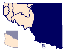
The Little Colorado River Plateau basin occupies the northeast portion of
Arizona (Figure 6). The basin contains about 27,300 square miles and lies
entirely within the Plateau uplands province. There are two distinct volcanic
fields in the basin: one in the west around Flagstaff and another in the
southeast in the White Mountains area. The Little Colorado River is the main
drainage for the basin. The river flows to the northwest from the White
Mountains area, leaving the basin near Cameron, Arizona. The Little Colorado
River Plateau basin is bordered on the north by the Arizona-Utah border, on the
east by the Arizona-New Mexico state line, on the south by the Mogollon Rim, and
on the west by U.S. Highway 89. The presence of U.S. Highway 89 does not have
any hydrogeologic significance to the basin boundary, but happens to coincide
with the lithologic and tectonic changes in the aquifer system.
Elevations in the Little Colorado River Plateau basin vary from 12,600 feet
above mean sea level at Humphrey's Peak, north of Flagstaff, to 4,200 feet above
mean sea level where the Little Colorado River flows out of the basin.
There are several local aquifers and three regional aquifers in the Little
Colorado River Plateau basin which saturate predominantly consolidated
sedimentary formations such as sandstones and limestones. These formations are
stacked on top of each other and are separated by impermeable shales and
siltstones. Water-bearing formations dip gently and gain thickness towards the
center of the basin causing the regional aquifers to occur at water-table
conditions at the southern and eastern periphery and becoming artesian
(confined) towards the center. Main recharge areas are also along the southern
and eastern peripheral belt.
Local aquifers are of great importance for domestic water supplies where the
three regional aquifers, the D-, N-, and C-aquifers, are too deep or have
unsuitable water quality. The local aquifers include alluvial deposits, which
occur in washes and stream channels throughout the basin, sedimentary and
volcanic rocks of the Bidahochi Formation, and various sandstones.
The alluvium along the Little Colorado River and its tributaries is an important
local source of water for domestic supplies (Figure 6). Water enters the
alluvium as discharge from the D, N, and C-aquifers, as streamflow infiltration,
or as direct rainfall. In thicker sections the alluvium is a steady source of
water, but smaller washes can go dry because of overuse or drought conditions.
Water quality varies greatly in the alluvial aquifers.
Radiochemical contamination is present in the alluvial aquifer along the Puerco
River. The elevated levels of gross alpha and gross beta are caused by the
movement of uranium-, radium-, and thorium-rich sediments from the 1979 Church
Rock uranium mine tailing pond spill in New Mexico (Webb and others, 1988) and
discharges of mine dewatering effluent which ceased in 1986 (U.S. Geological
Survey, 1991b). Current movement of radionuclides is due to discharges from the
sewage-treatment plant in Gallup, New Mexico (U.S. Geological Survey, 1991b).
This area is considered one of the principal water-quality problem areas in the
state (Arizona Department of Environmental Quality, 1990).
Basaltic volcanic rocks occur along the southeastern and southwestern edges of
the Little Colorado River Plateau basin (Figure 6). The basaltic rocks form an
irregular, eroded surface and vary in thickness from 0 to 3,000 feet.
Groundwater is found in fractures, cinder beds, and heavily weathered zones. In
the southeastern part of Navajo County, the saturated basaltic rocks, together
with underlying sedimentary rocks, locally are known as the Lakeside-Pinetop
aquifer. Water quality is generally very good and water is used for domestic,
stock, irrigation, and Lakeside/Pinetop public supply purposes.
The Bidahochi Formation forms a local aquifer in the northeastern part of
southern Apache County and near St. Johns (Figure 6). The Bidahochi Formation is
composed of sedimentary and volcanic rocks. The formation generally has three
members: a basal sandstone, a middle volcanic unit, and an upper sandstone
member. Principal groundwater withdrawal is from the upper sandstone unit.
Recharge is derived from rainfall onto the outcrop exposures.
Undifferentiated sandstones west of Show Low along the Mogollon Rim, form the
locally-named White Mountain and Springerville aquifers (Figure 6). These
aquifers receive recharge from rainfall and snowmelt infiltrating overlying
basaltic rock units. In southern Apache County, the basaltic rocks are in
hydraulic connection with the White Mountain and Springerville aquifers. Water
quality generally is good and water is used for domestic, stock and
Springerville and Eager public supply purposes.
Aquifers of the Little Colorado River Plateau basin contain large quantities of
groundwater in storage; however, they are in a sensitive relationship with the
Little Colorado River and its perennial tributaries. Lowering of hydrostatic
heads by excessive groundwater withdrawals may cause some perennial reaches of
the streams to dry up.
The regional aquifers are designated in descending order as the D-, N-, and C-aquifers. Each aquifer has a very large areal extent within the basin, and except for the D and N aquifers, there is little vertical hydrologic connection between them. They are the main source of water supply for municipal and industrial uses. The primary industrial uses include three electrical generating stations and a pulp mill.
The D-aquifer, one of the main aquifers north of the Little Colorado River, occurs over about a 3,125 square-mile area (Figure 7). It is used for domestic supplies in the north-central parts of the Little Colorado River Plateau basin where the N and C-aquifers are too deep or have very poor-quality water. The D-aquifer is made up of the Dakota, Cow Springs, and the Entrada Sandstones. Recharge to the D-aquifer is from local precipitation and runoff from the Defiance Uplift to the east. Groundwater flows to the north, west, and south from the areas of recharge (Arizona Department of Water Resources, 1988). Some water is lost from the aquifer by downward leakage into the underlying N-aquifer. Water in the D-aquifer is of marginal- to- unsuitable chemical quality for domestic use. Eychaner (1981) reported dissolved-solids concentration in water from the D-aquifer as seven times greater than in the N-aquifer; chloride concentration was 11 times greater; and sulfate concentration was 30 times greater than water from the N-aquifer. Dissolved solids concentrations range from 190 to 4,410 milligrams per liter, generally exceeding the recommended secondary maximum contaminant level of 500 milligrams per liter for drinking water (Arizona Department of Water Resources, 1988).
The N-aquifer has an areal extent of 6,250 square miles and also occurs north
of the Little Colorado River (Figure 8). The Navajo Sandstone and, where it is
present, the Wingate Sandstone are the main water-bearing units in the
N-aquifer. The aquifer generally is under water-table conditions (unconfined)
although an artesian (confined) zone exists in the Black Mesa area. Water-level
declines have occurred in this confined area as a result of groundwater
withdrawals for the Black Mesa Coal Mine slurry pipeline operated by Peabody
Coal. Water levels in the confined area are much more sensitive to pumping than
those in the unconfined area. Metered groundwater pumpage for the coal slurry
pipeline ranged from a low of 43 acre-feet in 1969 to a high of 4,740 acre-feet
in 1982; in 1989, 3,450 acre-feet were withdrawn (U.S. Geological Survey, 1992).
Precipitation falling on the exposed aquifer units is the main source of
recharge for the N-aquifer. Groundwater in the N-aquifer moves southward and
southeastward under Black Mesa. The flow divides under the mesa, moving westward
and eastward (Eychaner, 1981). Water in the N-aquifer is of good quality and
suitable for most uses. The N-aquifer is a source of groundwater supply for the
Navajo and Hopi Reservations, as well as the Black Mesa area.
The C-aquifer's main water-bearing units are the Kaibab Limestone, Coconino
Sandstone and upper sequences of the Supai Formation. The C-aquifer is the
largest aquifer in the Little Colorado River Plateau basin with an areal extent
of 21,655 square miles (Figure 9). The aquifer is generally utilized, however,
only south of the Little Colorado River and along the eastern edge of the basin
by communities such as Flagstaff, Heber, Overgaard, Show Low, Snowflake, and
Concho. North of the river, the C-aquifer is either too deep to be economically
useful or the water quality is unsuitable for most uses because of the high
content of dissolved salts. North of the Little Colorado River, total dissolved
solids concentrations in the C-aquifer range from 1,000 to 64,100 milligrams per
liter (Mann and Nemecek, 1983).
The C-aquifer is recharged by rainfall and by runoff from the San Francisco
Plateau, Mogollon Rim, White Mountains, and Defiance Uplift. Recharge to the
C-aquifer along the Mogollon Rim and White Mountains is estimated to be over
500,000 acre-feet per year (Arizona Department of Water Resources, 1988).
Groundwater in the C-Aquifer moves to the northwest from the large areas of
inflow on the south and east (Mann and Nemecek, 1983).
Aquifers of the Little Colorado River Plateau basin contain large quantities of
groundwater in storage, however, they are in a sensitive relationship with the
Little Colorado River and its perennial tributaries. Lowering of hydrostatic
heads by excessive groundwater withdrawals may cause some perennial reaches of
the streams to dry up (Mann, 1976).
The C-aquifer is the source of water for Sterling Spring at the head of Oak
Creek in the Verde River basin. Future development of this aquifer and the
limestone aquifer in the Flagstaff area should be preceded by an area-wide
hdyrologic study. Local heavy withdrawals from the C-aquifer may also cause
upward shifting of the salt water interface from the evaporites in the Supai
Formation near Joseph City (Mann and Nemecek, 1983).
The D- and C- regional aquifers are still in hydrostatic equilibrium
(steady-state); however, local groundwater sinks or cones of depression are
developing in areas of heavy pumpage (Arizona Department of Water Resources,
1991) such as the paper mill near Snowflake and three of the power plants:
Springerville Generating Station, Coronado Generating Station (St. Johns), and
Cholla Generating Station (Joseph City/Holbrook). The Navajo Generating Station,
near Page, uses surface water from Lake Powell. Water levels in wells that tap
the confined area of the N- aquifer are declining because of heavy withdrawals
for the Black Mesa coal mine slurry pipeline.