El
Niño and La Niña are extreme phases of
a naturally occurring climate cycle referred to as El Niño/Southern
Oscillation. Both terms refer to large-scale changes in sea-surface temperatures
(SSTs) across the eastern tropical Pacific Ocean. Usually, SSTs off South
America's west coast range from the 60s to 70s F, while they exceed 80 degrees F
in the normal "warm pool" of water located in the central and western
Pacific. This warm pool expands to cover the tropics during El Niño, but during
La Niña, the easterly trade winds strengthen and cold upwelling near along the
equator and the west coast of South America intensifies leading to below normal
SSTs. For more on these extreme phases of the climate cycle please refer to the
Science Corner links at the bottom of this web page.
The
ocean plays a large role in the atmospheric circulation pattern which determines
our weather and our climate. Due to unequal heating of the equator regions
versus the polar regions, temperature differences over land occur which need to
be removed by the atmosphere. These temperature differences are typically
reduced in the atmophere by the results of winds and through the generation of
areas of low pressure which bring warm air northward toward the poles and send
cold air southward toward the equator. Additionally, differences between land
and sea temperatures can create changing weather conditions along and adjacent
to coastlines. The same is true in the ocean, with El Niño/Southern Oscillation
and persistent ocean currents acting as mechanisms to relieve the continually
building and ebbing temperature gradients that are generated by uneven heating
and cooling of the ocean.
The
jetstream is a fast flowing ribbon of air in the atmosphere that tends to be the
primary mechanism which determines the weather pattern in a particular location.
Cold air tends to be located to the north of the jetstream with relatively
warmer air located to the south of the jetstream. Thus, the jetstream tends to
be located over areas where there is a strong contrast in temperature, which in
weather jargon is called a front. When the right conditions exist, an area of
low pressure can develop along the front, and act to relieve the temperature
contrast. Low pressure systems tend to develop underneath the jetstream and
propagate with it. An simple analogy to this would be to picture a leaf in a
stream of water. The leaf will flow with the stream and only go where the stream
takes it. Low pressure acts like this as well. Low pressure systems tend to be
located with the jetstream, so in order to have stormy weather, you usually need
to be near the jetstream.
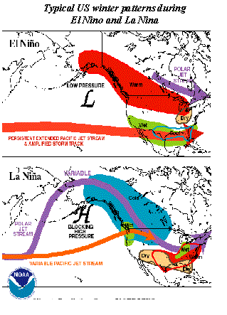
Well, these temperature contrasts don't only exist over the land, but also exist in the oceans. In the normal situation shown in the diagram above, warm water tends to be located over the western and central portions of the Pacific Ocean, with cooler water located over the eastern sections. Thunderstorms develop primarily over the warm water, which tends to be near Indonesia and the western portion of the Pacific Ocean. Energy from these thunderstorms acts to enhance the jetstream and make it stronger. In this normal situation, this enhanced energy in the jetstream can generate areas of low pressure along fronts which then travel eastward toward the west coast of the United States. These areas of low pressure are what give us our rain and snowstorms in the winter.
During
El Niño events, the warm pool of water, which typically is located over only
the western portions of the Pacific Ocean, spreads eastward toward South
America. Eventually it covers
the
entire Pacific Ocean along the equator. This results in an eastward movement of
thunderstorm complexes, which in turn leads to the energy from these
thunderstorms impacting the jetstream closer to the western United States. As
discussed above, the jetstream tends to be closely tied to locations where there
is a temperature contrast. In El Niño events, this temperature contrast tends
to be strongest near the central and eastern portions of the Pacific ocean,
which tends to keep the jetstream focused over this region. As can be seen in
the diagram to the left, this persistent jetstream tends to be focused over the
southern United States and over Arizona. A large area of low pressure tends to
develop in the Gulf of Alaska which acts to supply the jetstream with additional
energy to develop strong storms. Since storms tend to develop with and follow
the jetstream, Arizona tends to get more storms, and thus, more precipitation
under this particular pattern.
During
La Niña events, colder than normal water exists over the central and eastern
portions of the Pacific Ocean. This reduces the temperature difference of the
ocean in this region which makes the likelihood of a persistent jetstream over
the eastern portion of the Pacific Ocean less likely. As can be seen in the
diagram, typically high pressure builds over the Gulf of Alaska, which sends the
jetstream well north into Alaska and then diving southward into the Midwest of
the United States. Occasionally, a portion of the jetstream will push through
the ridge of high pressure to impact the western United States, especially the
northwest coast. This leaves Arizona well removed from the jetstream, and thus
leads to fewer storms, and less precipitation under this pattern.
|
Year |
Yearly
Precipitation |
Snowfall
Season |
SST State |
|
1996 |
11.81" |
28.5" |
La Nina |
|
1997 |
17.84" |
107.5" |
Normal |
|
1998 |
27.35" |
136.7" |
El Nino |
|
1999 |
15.79" |
72.0" |
La Nina |
|
2000 |
15.40" |
74.4" |
La Nina |
|
Normal |
22.80" |
108.8" |
|
The
table above looks back over the last five precipitation years for northern
Arizona. The values in the table are from the official Flagstaff climate record
as recorded by the National Weather Service. The precipitation column represents
all precipitation, both in the form of rain and melted snow, that was recorded
in Flagstaff from January through December of the year shown. Snowfall data
begins in July of the year specified and continues through June of the following
year, in order to encompass the entire winter snowfall season. The column
designated as SST State refers to the deviation of sea surface temperatures in
the Pacific Ocean and if either an El Niño or La Niña event were occurring.
It
is fairly easy to see the strong association that the sea surface temperatures
in the Pacific Ocean have had on our precipitation amounts here in northern
Arizona. During El Niño, we tend to get more precipitation and more snowfall,
while during La Niña, we tend to receive less precipitation and snowfall.
During "normal" states of sea surface temperature, our chances of
having near normal precipitation are greater, however we still can have very dry
or very wet years, just due to the variability of weather. El Niño and La Niña
don't make it a 100% guarantee that it will be wetter or drier than normal, but
they tend to tip the scales in that direction. As we all know in northern
Arizona, there is no 100% guarantee when it comes to weather!
Numerous
webpages can be found on the internet with information regarding La Niña. Those
links provided below are only a few of the locations on the web where you can
find more information regarding this ocean-atmospheric phenomenon.